Verkhnebakanskiy night lights from space
Night Light of Verkhnebakanskiy (Krasnodarskiy) from space (Russia) Src. Average luminocity for 10x10km area is 20.8127% and for 50x50km: 11.2375%.
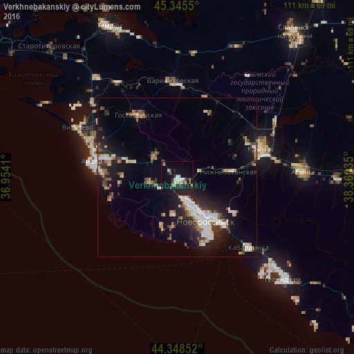
Analysis of Verkhnebakanskiy night lights 2016
Square area 10x10 km:
 2.86%
2.86%90-99
2.54%80-89
3.65%70-79
0.48%60-69
0.48%50-59
3.81%40-49
1.75%30-39
3.17%20-29
6.35%10-19
26.03%0-9
48.89%Square area 50x50 km:
1.64%90-99
2.2%80-89
0.97%70-79
0.98%60-69
1.2%50-59
1.25%40-49
1.35%30-39
1.65%20-29
3.55%10-19
8.39%0-9
76.83%Clear (daylight) street map image can be seen on geolist.org.
Map coordinates:
45° 20' 43.8" North, 36° 57' 14.8" East
44° 50' 57" North, 37° 39' 26" East
44° 20' 54.7" North, 38° 21' 37.3" East
Some cities around Verkhnebakanskiy sort by population:
• Novorossiysk
16.4 km =10.2 mi,  147°
147°
• Krymsk
27.8 km =17.3 mi,  71°
71°
• Anapa
27.3 km =17 mi,  280°
280°
• Anapskaya
22 km =13.7 mi, 283°
• Gostagayevskaya
22.7 km =14.1 mi,  328°
328°
• Rayevskaya
8.1 km =5 mi,  259°
259°
• Myskhako
22.8 km =14.2 mi,  157°
157°
• Gayduk
7.9 km =4.9 mi, 154°
867425 (p: 6,746)
Sources (retrieved 2019-11-25):
» Earth at Night: Flat Maps 2012, 2016