Gzhel’ night lights from space
Night Light of Gzhel’ (Moscow Oblast) from space (Russia) Src. Average luminocity for 10x10km area is 9.7832% and for 50x50km: 18.9001%.
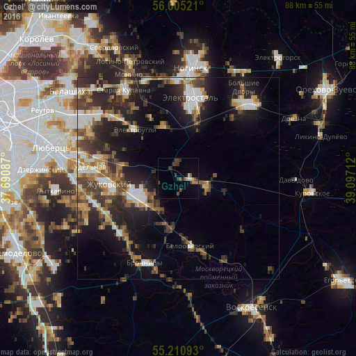
Analysis of Gzhel’ night lights 2016
Square area 10x10 km:
 0.38%
0.38%90-99
0.75%80-89
0.88%70-79
0.75%60-69
1.75%50-59
1%40-49
2.76%30-39
4.01%20-29
1.75%10-19
1.88%0-9
84.09%Square area 50x50 km:
2.49%90-99
3.05%80-89
1.9%70-79
2.06%60-69
2.73%50-59
2.73%40-49
3.09%30-39
3.95%20-29
7.08%10-19
11.02%0-9
59.89%Clear (daylight) street map image can be seen on geolist.org.
Map coordinates:
56° 0' 18.8" North, 37° 41' 27.1" East
55° 36' 36.3" North, 38° 23' 38.4" East
55° 12' 39.3" North, 39° 5' 49.6" East
Some cities around Gzhel’ sort by population:
• Zhukovskiy
17.3 km =10.7 mi,  264°
264°
• Ramenskoye
11.4 km =7.1 mi,  245°
245°
• Fryazevo
14.4 km =8.9 mi,  17°
17°
• Elektrougli
17.2 km =10.7 mi,  317°
317°
• Beloozërskiy
17 km =10.6 mi,  169°
169°
• Il’inskiy
17.3 km =10.7 mi,  273°
273°
• Kratovo
13.7 km =8.5 mi, 264°
• Imeni Vorovskogo
14.2 km =8.8 mi,  341°
341°
557657 (p: 7,000)
Sources (retrieved 2019-11-25):
» Earth at Night: Flat Maps 2012, 2016