Imeni Vorovskogo night lights from space
Night Light of Imeni Vorovskogo (Moscow Oblast) from space (Russia) Src. Average luminocity for 10x10km area is 10.0754% and for 50x50km: 29.1854%.
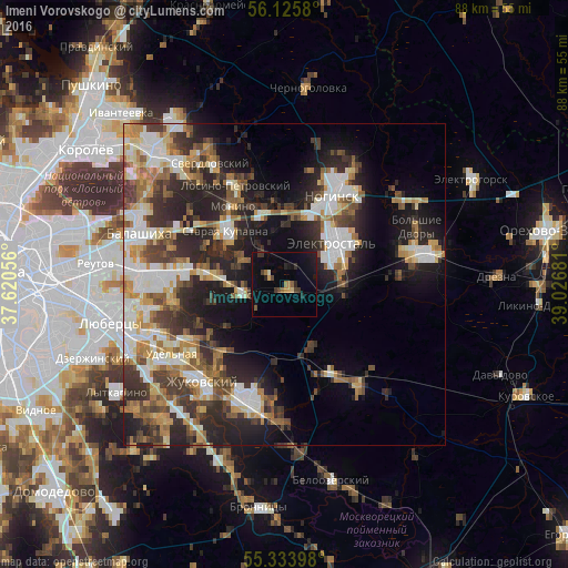
Analysis of Imeni Vorovskogo night lights 2016
Square area 10x10 km:
 0%
0%90-99
0.48%80-89
0.72%70-79
1.56%60-69
1.44%50-59
1.08%40-49
1.56%30-39
2.63%20-29
2.27%10-19
7.89%0-9
80.38%Square area 50x50 km:
4.96%90-99
5.66%80-89
3.13%70-79
3.57%60-69
4.23%50-59
3.68%40-49
4.07%30-39
5.59%20-29
9.78%10-19
11.79%0-9
43.53%Clear (daylight) street map image can be seen on geolist.org.
Map coordinates:
56° 7' 32.9" North, 37° 37' 14" East
55° 43' 54.8" North, 38° 19' 25.2" East
55° 20' 2.3" North, 39° 1' 36.5" East
Some cities around Imeni Vorovskogo sort by population:
• Elektrostal’
10 km =6.2 mi,  50°
50°
• Fryazevo
8.8 km =5.5 mi,  89°
89°
• Zarya
14.5 km =9 mi,  280°
280°
• Staraya Kupavna
12.3 km =7.6 mi,  313°
313°
• Elektrougli
7.2 km =4.5 mi,  263°
263°
• Kupavna
12.1 km =7.5 mi, 277°
• Obukhovo
11.7 km =7.3 mi,  344°
344°
• Gzhel’
14.2 km =8.8 mi,  161°
161°
556463 (p: 5,303)
Sources (retrieved 2019-11-25):
» Earth at Night: Flat Maps 2012, 2016