Gorbunki night lights from space
Night Light of Gorbunki (Leningradskaya Oblast') from space (Russia) Src. Average luminocity for 10x10km area is 56.881% and for 50x50km: 35.0142%.
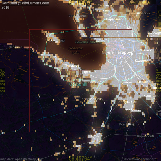
Analysis of Gorbunki night lights 2016
Square area 10x10 km:
 10.5%
10.5%90-99
14.39%80-89
5.84%70-79
8.66%60-69
6.06%50-59
9.63%40-49
3.57%30-39
13.31%20-29
15.58%10-19
12.45%0-9
0%Square area 50x50 km:
16.74%90-99
6.72%80-89
2.04%70-79
2.54%60-69
1.83%50-59
2.04%40-49
1.12%30-39
2.96%20-29
7.94%10-19
11.77%0-9
44.32%Clear (daylight) street map image can be seen on geolist.org.
Map coordinates:
60° 9' 53.1" North, 29° 16' 54" East
59° 48' 47.1" North, 29° 59' 5.2" East
59° 27' 27.5" North, 30° 41' 16.5" East
Some cities around Gorbunki sort by population:
• Peterhof
9.1 km =5.7 mi,  328°
328°
• Petrodvorets
13.8 km =8.6 mi,  311°
311°
• Uritsk
11 km =6.8 mi,  74°
74°
• Sosnovaya Polyana
9.4 km =5.8 mi, 74°
• Krasnoye Selo
10.2 km =6.3 mi,  144°
144°
• Gorelovo
9.5 km =5.9 mi,  118°
118°
• Strel'na
5.2 km =3.2 mi,  33°
33°
• Ol’gino
4.4 km =2.7 mi, 307°
560255 (p: 7,566)
Sources (retrieved 2019-11-25):
» Earth at Night: Flat Maps 2012, 2016