Dzhalil’ night lights from space
Night Light of Dzhalil’ (Tatarstan Republic) from space (Russia) Src. Average luminocity for 10x10km area is 5.0827% and for 50x50km: 2.7731%.
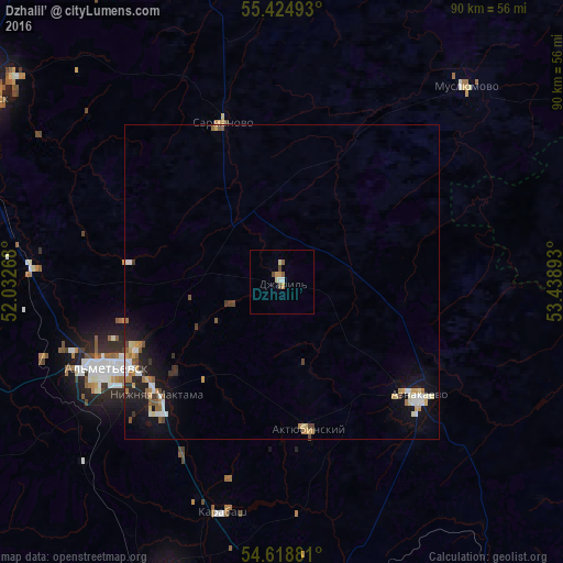
Analysis of Dzhalil’ night lights 2016
Square area 10x10 km:
 0.38%
0.38%90-99
0.63%80-89
1%70-79
1.5%60-69
0%50-59
1.13%40-49
1.38%30-39
0%20-29
0%10-19
0%0-9
93.98%Square area 50x50 km:
0.31%90-99
0.44%80-89
0.35%70-79
0.43%60-69
0.35%50-59
0.34%40-49
0.33%30-39
0.25%20-29
0.52%10-19
2.32%0-9
94.35%Clear (daylight) street map image can be seen on geolist.org.
Map coordinates:
55° 25' 29.7" North, 52° 1' 57.6" East
55° 1' 26" North, 52° 44' 8.9" East
54° 37' 7.7" North, 53° 26' 20.1" East
Some cities around Dzhalil’ sort by population:
• Al’met’yevsk
29.9 km =18.6 mi,  243°
243°
• Leninogorsk
50.1 km =31.1 mi,  200°
200°
• Zainsk
53.6 km =33.3 mi,  307°
307°
• Nizhnyaya Maktama
26.5 km =16.5 mi,  227°
227°
• Aktyubinskiy
23.8 km =14.8 mi,  169°
169°
• Muslyumovo
42.6 km =26.5 mi,  43°
43°
• Sarmanovo
27.4 km =17 mi,  340°
340°
• Karabash
38.1 km =23.7 mi,  194°
194°
563681 (p: 14,797)
Sources (retrieved 2019-11-25):
» Earth at Night: Flat Maps 2012, 2016