Bronnitsy night lights from space
Night Light of Bronnitsy (Moscow Oblast) from space (Russia) Src. Average luminocity for 10x10km area is 19.6136% and for 50x50km: 14.6215%.
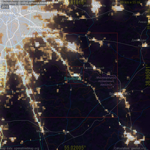
Analysis of Bronnitsy night lights 2016
Square area 10x10 km:
 1.32%
1.32%90-99
3.11%80-89
1.08%70-79
1.56%60-69
3.71%50-59
4.9%40-49
1.79%30-39
3.11%20-29
2.99%10-19
22.97%0-9
53.47%Square area 50x50 km:
1.46%90-99
2.08%80-89
1.37%70-79
1.64%60-69
2.4%50-59
2.38%40-49
2.78%30-39
3.41%20-29
5.44%10-19
9.3%0-9
67.75%Clear (daylight) street map image can be seen on geolist.org.
Map coordinates:
55° 49' 5.4" North, 37° 33' 31.5" East
55° 25' 16" North, 38° 15' 42.8" East
55° 1' 12.2" North, 38° 57' 54" East
Some cities around Bronnitsy sort by population:
• Zhukovskiy
21.3 km =13.2 mi,  335°
335°
• Ramenskoye
16.3 km =10.1 mi,  353°
353°
• Andreyevskoye
25.9 km =16.1 mi,  305°
305°
• Beloozërskiy
12.2 km =7.6 mi,  69°
69°
• Konobeyevo
25.3 km =15.7 mi,  93°
93°
• Il’inskiy
23.8 km =14.8 mi, 337°
• Gzhel’
22.6 km =14 mi,  21°
21°
• Kratovo
20.3 km =12.6 mi, 344°
571557 (p: 18,645)
Sources (retrieved 2019-11-25):
» Earth at Night: Flat Maps 2012, 2016