Beloomut night lights from space
Night Light of Beloomut (Moscow Oblast) from space (Russia) Src. Average luminocity for 10x10km area is 0.1077% and for 50x50km: 1.6774%.
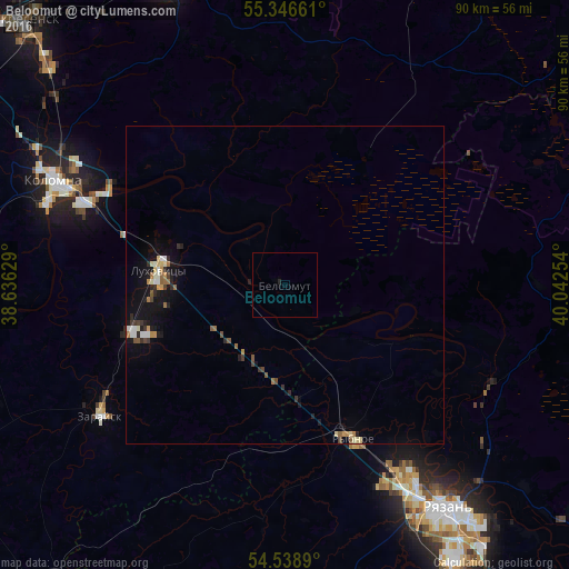
Analysis of Beloomut night lights 2016
Square area 10x10 km:
 0%
0%90-99
0%80-89
0%70-79
0%60-69
0%50-59
0%40-49
0%30-39
0%20-29
0.24%10-19
0.24%0-9
99.52%Square area 50x50 km:
0.13%90-99
0.25%80-89
0.18%70-79
0.18%60-69
0.23%50-59
0.25%40-49
0.17%30-39
0.26%20-29
0.36%10-19
1.52%0-9
96.47%Clear (daylight) street map image can be seen on geolist.org.
Map coordinates:
55° 20' 47.8" North, 38° 38' 10.6" East
54° 56' 41.2" North, 39° 20' 21.9" East
54° 32' 20" North, 40° 2' 33.1" East
Some cities around Beloomut sort by population:
• Ryazan’
41.9 km =26 mi,  147°
147°
• Kolomna
38.8 km =24.1 mi,  292°
292°
• Yegor’yevsk
52.5 km =32.6 mi,  338°
338°
• Lukhovitsy
19.2 km =11.9 mi,  280°
280°
• Ozëry
51.3 km =31.9 mi,  259°
259°
• Zaraysk
35.9 km =22.3 mi,  235°
235°
• Rybnoye
26.7 km =16.6 mi, 154°
• Polyany
40.3 km =25 mi,  128°
128°
577908 (p: 6,971)
Sources (retrieved 2019-11-25):
» Earth at Night: Flat Maps 2012, 2016