Agalatovo night lights from space
Night Light of Agalatovo (Leningradskaya Oblast') from space (Russia) Src. Average luminocity for 10x10km area is 24.2924% and for 50x50km: 24.7674%.
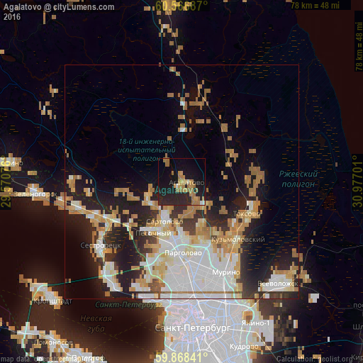
Analysis of Agalatovo night lights 2016
Square area 10x10 km:
 0.41%
0.41%90-99
1.34%80-89
1.03%70-79
6.4%60-69
10.85%50-59
1.03%40-49
0%30-39
0.1%20-29
16.74%10-19
28.41%0-9
33.68%Square area 50x50 km:
5.63%90-99
5.2%80-89
2.84%70-79
3.65%60-69
4.8%50-59
1.75%40-49
0.86%30-39
1.93%20-29
6.32%10-19
10.5%0-9
56.5%Clear (daylight) street map image can be seen on geolist.org.
Map coordinates:
60° 34' 0.7" North, 29° 34' 14.7" East
60° 13' 10.2" North, 30° 16' 26" East
59° 52' 6.3" North, 30° 58' 37.2" East
Some cities around Agalatovo sort by population:
• Parnas
17.2 km =10.7 mi,  166°
166°
• Sertolovo
9.3 km =5.8 mi,  205°
205°
• Vaskelovo
20.1 km =12.5 mi,  12°
12°
• Pargolovo
15.4 km =9.6 mi,  179°
179°
• Pesochnyy
12.3 km =7.6 mi, 209°
• Bugry
17.7 km =11 mi,  158°
158°
• Shuvalovo
19 km =11.8 mi, 176°
• Toksovo
15.3 km =9.5 mi,  118°
118°
584059 (p: 5,028)
Sources (retrieved 2019-11-25):
» Earth at Night: Flat Maps 2012, 2016