Toksovo night lights from space
Night Light of Toksovo (Leningradskaya Oblast') from space (Russia) Src. Average luminocity for 10x10km area is 36.6157% and for 50x50km: 28.2164%.
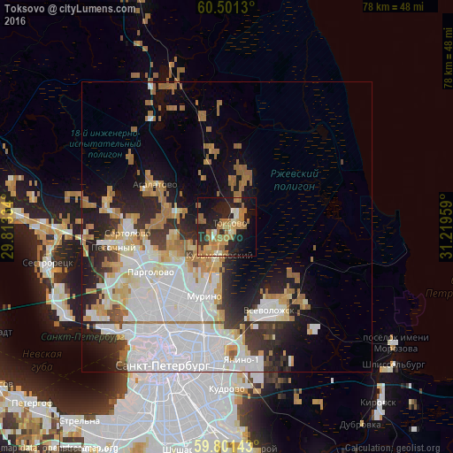
Analysis of Toksovo night lights 2016
Square area 10x10 km:
 0.41%
0.41%90-99
5.58%80-89
3.41%70-79
9.92%60-69
15.19%50-59
2.48%40-49
0%30-39
2.69%20-29
17.46%10-19
25.41%0-9
17.46%Square area 50x50 km:
10.47%90-99
5.47%80-89
2.48%70-79
3.05%60-69
4.26%50-59
1.62%40-49
0.97%30-39
2.37%20-29
5.29%10-19
8.27%0-9
55.74%Clear (daylight) street map image can be seen on geolist.org.
Map coordinates:
60° 30' 4.7" North, 29° 48' 48" East
60° 9' 11.6" North, 30° 30' 59.3" East
59° 48' 5.1" North, 31° 13' 10.5" East
Some cities around Toksovo sort by population:
• Grazhdanka
14.4 km =8.9 mi,  205°
205°
• Parnas
13.1 km =8.1 mi,  225°
225°
• Pargolovo
15.5 km =9.6 mi,  238°
238°
• Novoye Devyatkino
10.1 km =6.3 mi,  190°
190°
• Murino
12.2 km =7.6 mi,  196°
196°
• Bugry
11.4 km =7.1 mi,  217°
217°
• Romanovka
16.3 km =10.1 mi,  137°
137°
• Agalatovo
15.3 km =9.5 mi,  298°
298°
482443 (p: 5,863)
Sources (retrieved 2019-11-25):
» Earth at Night: Flat Maps 2012, 2016