Bugry night lights from space
Night Light of Bugry (Leningradskaya Oblast') from space (Russia) Src. Average luminocity for 10x10km area is 90.5217% and for 50x50km: 40.3635%.
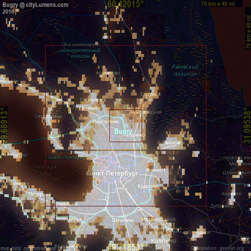
Analysis of Bugry night lights 2016
Square area 10x10 km:
 44.11%
90-99
23.66%80-89
10.33%70-79
11.78%60-69
7.23%50-59
0.31%40-49
2.27%30-39
0.31%20-29
0%10-19
0%0-9
0%Square area 50x50 km:
17.66%90-99
7.24%80-89
3.16%70-79
3.82%60-69
4.45%50-59
1.62%40-49
1.56%30-39
3.46%20-29
8.2%10-19
12.09%0-9
36.74%Clear (daylight) street map image can be seen on geolist.org.
Map coordinates:
60° 25' 12.5" North, 29° 41' 20.9" East
60° 4' 16.4" North, 30° 23' 32.1" East
59° 43' 6.7" North, 31° 5' 43.4" East
Some cities around Bugry sort by population:
• Akademicheskoe
6.4 km =4 mi,  178°
178°
• Ozerki
5.7 km =3.5 mi,  231°
231°
• Grazhdanka
4 km =2.5 mi,  169°
169°
• Parnas
2.4 km =1.5 mi,  265°
265°
• Sosnovka
6.5 km =4 mi,  201°
201°
• Novoye Devyatkino
5.1 km =3.2 mi,  99°
99°
• Murino
4.2 km =2.6 mi,  127°
127°
• Shuvalovo
6 km =3.7 mi,  245°
245°
824070 (p: 6,154)
Sources (retrieved 2019-11-25):
» Earth at Night: Flat Maps 2012, 2016