Kovin night lights from space
Night Light of Kovin (Vojvodina) from space (Serbia) Src. Average luminocity for 10x10km area is 16.3% and for 50x50km: 10.4596%.
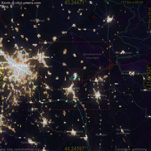
Analysis of Kovin night lights 2016
Square area 10x10 km:
 3.18%
3.18%90-99
2.88%80-89
0.61%70-79
0%60-69
1.36%50-59
3.33%40-49
1.06%30-39
0.76%20-29
0.91%10-19
23.64%0-9
62.27%Square area 50x50 km:
1.3%90-99
1.72%80-89
0.93%70-79
0.77%60-69
1.23%50-59
1.3%40-49
1.5%30-39
1.38%20-29
2.43%10-19
9.5%0-9
77.95%Clear (daylight) street map image can be seen on geolist.org.
Map coordinates:
45° 14' 41" North, 20° 16' 22.8" East
44° 44' 51" North, 20° 58' 34" East
44° 14' 45.5" North, 21° 40' 45.3" East
Some cities around Kovin sort by population:
• Belgrade
40.8 km =25.4 mi,  278°
278°
• Pančevo
29.8 km =18.5 mi,  297°
297°
• Smederevo
10 km =6.2 mi,  202°
202°
• Požarevac
21.8 km =13.5 mi,  129°
129°
• Bela Crkva
38.6 km =24 mi,  64°
64°
• Banatski Karlovac
33.8 km =21 mi,  5°
5°
• Crepaja
39.6 km =24.6 mi,  317°
317°
• Vladimirovac
32.7 km =20.3 mi,  344°
344°
789168 (p: 14,250)
Sources (retrieved 2019-11-25):
» Earth at Night: Flat Maps 2012, 2016