Crepaja night lights from space
Night Light of Crepaja (Vojvodina) from space (Serbia) Src. Average luminocity for 10x10km area is 7.1952% and for 50x50km: 16.2026%.
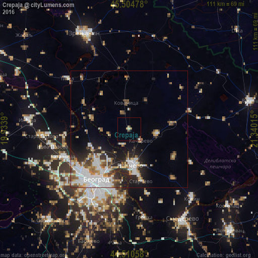
Analysis of Crepaja night lights 2016
Square area 10x10 km:
 0.63%
0.63%90-99
0.95%80-89
1.27%70-79
0.79%60-69
0.79%50-59
0.79%40-49
0.48%30-39
0.63%20-29
0.63%10-19
0.63%0-9
92.38%Square area 50x50 km:
3.92%90-99
3.76%80-89
1.27%70-79
1.57%60-69
1.85%50-59
1.65%40-49
1.75%30-39
1.75%20-29
4.14%10-19
5.87%0-9
72.46%Clear (daylight) street map image can be seen on geolist.org.
Map coordinates:
45° 30' 17.2" North, 19° 56' 2" East
45° 0' 35.4" North, 20° 38' 13.3" East
44° 30' 38.1" North, 21° 20' 24.5" East
Some cities around Crepaja sort by population:
• Belgrade
26.6 km =16.5 mi,  210°
210°
• Zemun
26 km =16.2 mi,  225°
225°
• Pančevo
15.4 km =9.6 mi,  178°
178°
• Kovačica
11.4 km =7.1 mi,  353°
353°
• Debeljača
7.3 km =4.5 mi,  337°
337°
• Padina
14.2 km =8.8 mi,  30°
30°
• Banatski Karlovac
30.3 km =18.8 mi,  81°
81°
• Vladimirovac
18.1 km =11.2 mi, 82°
791887 (p: 5,369)
Sources (retrieved 2019-11-25):
» Earth at Night: Flat Maps 2012, 2016