Valea Călugărească night lights from space
Night Light of Valea Călugărească (Prahova) from space (Romania) Src. Average luminocity for 10x10km area is 10.9841% and for 50x50km: 6.4078%.
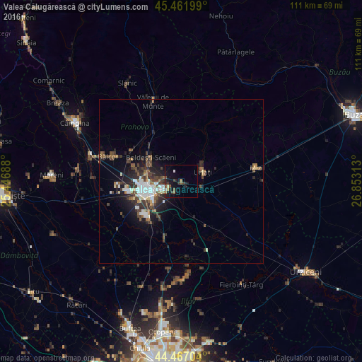
Analysis of Valea Călugărească night lights 2016
Square area 10x10 km:
 0.63%
0.63%90-99
0.63%80-89
0.79%70-79
0.95%60-69
2.22%50-59
2.38%40-49
1.27%30-39
1.59%20-29
4.6%10-19
12.06%0-9
72.86%Square area 50x50 km:
1.04%90-99
1.12%80-89
0.34%70-79
0.37%60-69
0.78%50-59
0.89%40-49
1.4%30-39
1.43%20-29
2.17%10-19
3.8%0-9
86.66%Clear (daylight) street map image can be seen on geolist.org.
Map coordinates:
45° 27' 43.2" North, 25° 26' 48.8" East
44° 58' 0" North, 26° 9' 0" East
44° 28' 1.3" North, 26° 51' 11.3" East
Some cities around Valea Călugărească sort by population:
• Ploieşti
10.7 km =6.6 mi,  259°
259°
• Urlaţi
6.8 km =4.2 mi,  74°
74°
• Boldeşti-Scăeni
11.8 km =7.3 mi,  308°
308°
• Bucov
5.2 km =3.2 mi,  270°
270°
• Blejoi
11.1 km =6.9 mi,  289°
289°
• Berceni
4.5 km =2.8 mi,  215°
215°
• Albeşti-Paleologu
5.6 km =3.5 mi,  109°
109°
• Râfov
11.2 km =7 mi,  186°
186°
663863 (p: 10,378)
Sources (retrieved 2019-11-25):
» Earth at Night: Flat Maps 2012, 2016