Râfov night lights from space
Night Light of Râfov (Prahova) from space (Romania) Src. Average luminocity for 10x10km area is 2.4492% and for 50x50km: 7.4762%.
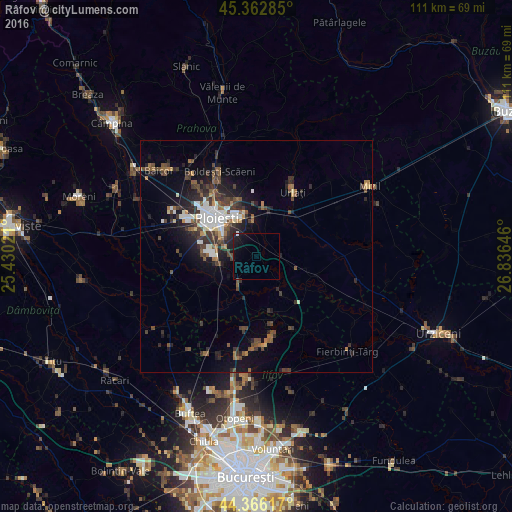
Analysis of Râfov night lights 2016
Square area 10x10 km:
 0%
0%90-99
0.32%80-89
0%70-79
0%60-69
0%50-59
0%40-49
0%30-39
0%20-29
0.63%10-19
6.98%0-9
92.06%Square area 50x50 km:
1.06%90-99
1.14%80-89
0.38%70-79
0.39%60-69
0.98%50-59
1.14%40-49
1.86%30-39
1.76%20-29
2.45%10-19
4.53%0-9
84.29%Clear (daylight) street map image can be seen on geolist.org.
Map coordinates:
45° 21' 46.3" North, 25° 25' 48.8" East
44° 52' 0" North, 26° 7' 60" East
44° 21' 58.2" North, 26° 50' 11.3" East
Some cities around Râfov sort by population:
• Valea Călugărească
11.2 km =7 mi,  6°
6°
• Bucov
11.8 km =7.3 mi,  340°
340°
• Bărcăneşti
6.8 km =4.2 mi,  285°
285°
• Puchenii Mari
6.8 km =4.2 mi,  215°
215°
• Brazii de Sus
9.2 km =5.7 mi,  270°
270°
• Berceni
7.5 km =4.7 mi,  349°
349°
• Albeşti-Paleologu
11.4 km =7.1 mi,  35°
35°
• Gorgota
10.1 km =6.3 mi,  203°
203°
668911 (p: 5,472)
Sources (retrieved 2019-11-25):
» Earth at Night: Flat Maps 2012, 2016