Boldeşti-Scăeni night lights from space
Night Light of Boldeşti-Scăeni (Prahova) from space (Romania) Src. Average luminocity for 10x10km area is 12.7698% and for 50x50km: 7.2462%.
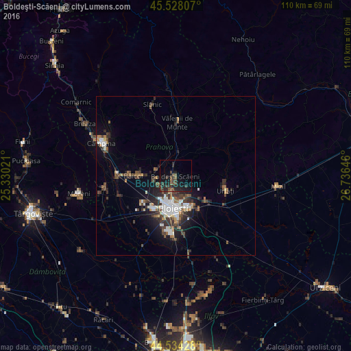
Analysis of Boldeşti-Scăeni night lights 2016
Square area 10x10 km:
 0%
0%90-99
0%80-89
0%70-79
0%60-69
0%50-59
5.56%40-49
5.08%30-39
4.44%20-29
7.46%10-19
17.14%0-9
60.32%Square area 50x50 km:
1.15%90-99
1.23%80-89
0.38%70-79
0.42%60-69
0.84%50-59
1.03%40-49
1.66%30-39
1.56%20-29
2.34%10-19
4.26%0-9
85.14%Clear (daylight) street map image can be seen on geolist.org.
Map coordinates:
45° 31' 41.1" North, 25° 19' 48.8" East
45° 1' 60" North, 26° 1' 60" East
44° 32' 3.4" North, 26° 44' 11.3" East
Some cities around Boldeşti-Scăeni sort by population:
• Ploieşti
9.4 km =5.8 mi,  188°
188°
• Valea Călugărească
11.8 km =7.3 mi,  128°
128°
• Bucov
8.4 km =5.2 mi,  152°
152°
• Plopeni
6.6 km =4.1 mi,  285°
285°
• Blejoi
3.9 km =2.4 mi,  199°
199°
• Berceni
12.9 km =8 mi, 149°
• Gura Viţioarei
13 km =8.1 mi,  0°
0°
• Păuleşti
5.4 km =3.4 mi,  226°
226°
684280 (p: 11,460)
Sources (retrieved 2019-11-25):
» Earth at Night: Flat Maps 2012, 2016