Urlaţi night lights from space
Night Light of Urlaţi (Prahova) from space (Romania) Src. Average luminocity for 10x10km area is 5.9% and for 50x50km: 5.7578%.
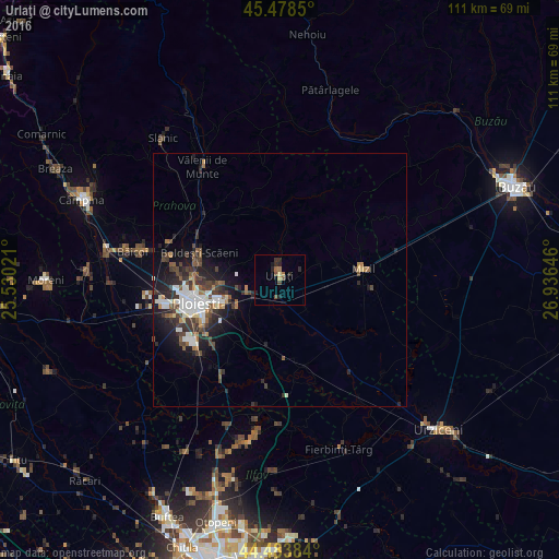
Analysis of Urlaţi night lights 2016
Square area 10x10 km:
 0%
0%90-99
0%80-89
0.79%70-79
0.48%60-69
1.59%50-59
1.11%40-49
1.75%30-39
0.63%20-29
4.6%10-19
1.11%0-9
87.94%Square area 50x50 km:
1%90-99
1.07%80-89
0.29%70-79
0.36%60-69
0.65%50-59
0.75%40-49
1.19%30-39
1.35%20-29
2.09%10-19
3.49%0-9
87.77%Clear (daylight) street map image can be seen on geolist.org.
Map coordinates:
45° 28' 42.6" North, 25° 31' 48.8" East
44° 58' 60" North, 26° 13' 60" East
44° 29' 1.8" North, 26° 56' 11.3" East
Some cities around Urlaţi sort by population:
• Valea Călugărească
6.8 km =4.2 mi,  254°
254°
• Bucov
11.9 km =7.4 mi,  261°
261°
• Berceni
10.7 km =6.6 mi,  238°
238°
• Albeşti-Paleologu
3.9 km =2.4 mi,  199°
199°
• Colceag
9.9 km =6.2 mi,  111°
111°
• Râfov
15.2 km =9.4 mi,  211°
211°
• Ceptura de Sus
7.5 km =4.7 mi,  60°
60°
• Moceşti
7.5 km =4.7 mi,  10°
10°
664150 (p: 11,798)
Sources (retrieved 2019-11-25):
» Earth at Night: Flat Maps 2012, 2016