Târgu Secuiesc night lights from space
Night Light of Târgu Secuiesc (Covasna) from space (Romania) Src. Average luminocity for 10x10km area is 1.9616% and for 50x50km: 0.3998%.
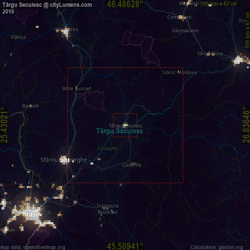
Analysis of Târgu Secuiesc night lights 2016
Square area 10x10 km:
 0%
0%90-99
0%80-89
0%70-79
1.14%60-69
0%50-59
0.57%40-49
0.43%30-39
0.14%20-29
1.14%10-19
0.57%0-9
96.02%Square area 50x50 km:
0.05%90-99
0.02%80-89
0.06%70-79
0.06%60-69
0.04%50-59
0.05%40-49
0.04%30-39
0.05%20-29
0.14%10-19
0.21%0-9
99.29%Clear (daylight) street map image can be seen on geolist.org.
Map coordinates:
46° 29' 10.6" North, 25° 25' 48.8" East
46° 0' 0" North, 26° 7' 60" East
45° 30' 33.9" North, 26° 50' 11.3" East
Some cities around Târgu Secuiesc sort by population:
• Sfântu Gheorghe
30.9 km =19.2 mi,  241°
241°
• Covasna
17.1 km =10.6 mi,  166°
166°
• Baraolt
42 km =26.1 mi,  281°
281°
• Întorsura Buzăului
36.1 km =22.4 mi,  192°
192°
• Prejmer
42.4 km =26.3 mi,  222°
222°
• Sâncrăieni
41.6 km =25.8 mi,  327°
327°
• Tulnici
42.3 km =26.3 mi,  102°
102°
• Zagon
26 km =16.2 mi,  182°
182°
665000 (p: 20,067)
Sources (retrieved 2019-11-25):
» Earth at Night: Flat Maps 2012, 2016