Rucăr night lights from space
Night Light of Rucăr (Arges) from space (Romania) Src. Average luminocity for 10x10km area is 0% and for 50x50km: 1.2307%.
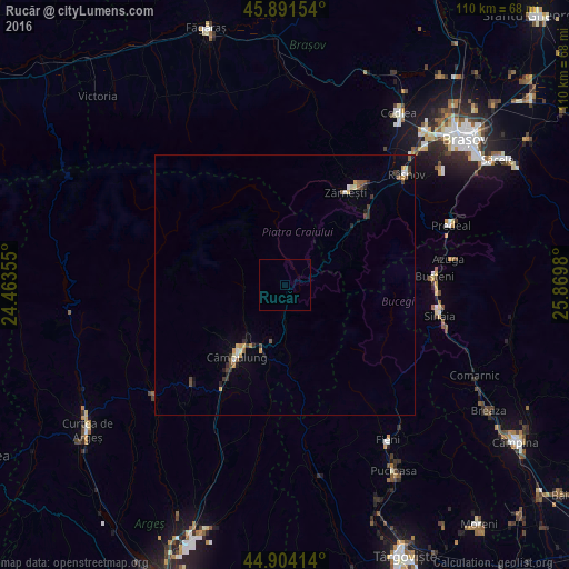
Analysis of Rucăr night lights 2016
Square area 10x10 km:
100  0%
0%
90-99 0%
80-89 0%
70-79 0%
60-69 0%
50-59 0%
40-49 0%
30-39 0%
20-29 0%
10-19 0%
0-9 100%
0%90-99
0%80-89
0%70-79
0%60-69
0%50-59
0%40-49
0%30-39
0%20-29
0%10-19
0%0-9
100%Square area 50x50 km:
100 0.07%
90-99 0.12%
80-89 0.15%
70-79 0.22%
60-69 0.05%
50-59 0.23%
40-49 0.28%
30-39 0.22%
20-29 0.25%
10-19 0.33%
0-9 98.06%
0.07%90-99
0.12%80-89
0.15%70-79
0.22%60-69
0.05%50-59
0.23%40-49
0.28%30-39
0.22%20-29
0.25%10-19
0.33%0-9
98.06%Clear (daylight) street map image can be seen on geolist.org.
Map coordinates:
45° 53' 29.5" North, 24° 27' 48.8" East
45° 24' 0" North, 25° 10' 0" East
44° 54' 14.9" North, 25° 52' 11.3" East
Some cities around Rucăr sort by population:
• Zărnești
21.4 km =13.3 mi,  33°
33°
• Râşnov
30.1 km =18.7 mi,  47°
47°
• Sinaia
30.5 km =19 mi,  100°
100°
• Buşteni
28.6 km =17.8 mi,  90°
90°
• Bărbuleţu
31.4 km =19.5 mi,  160°
160°
• Vulcan
32.4 km =20.1 mi,  36°
36°
• Bran
19.3 km =12 mi, 47°
• Moroeni
29.2 km =18.1 mi,  134°
134°
668542 (p: 6,142)
Sources (retrieved 2019-11-25):
» Earth at Night: Flat Maps 2012, 2016