Buşteni night lights from space
Night Light of Buşteni (Prahova) from space (Romania) Src. Average luminocity for 10x10km area is 10.0952% and for 50x50km: 2.7053%.
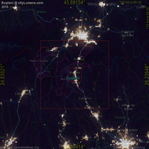
Analysis of Buşteni night lights 2016
Square area 10x10 km:
 0.63%
0.63%90-99
0.63%80-89
1.75%70-79
2.38%60-69
0.32%50-59
2.06%40-49
2.86%30-39
0.48%20-29
0.95%10-19
0.63%0-9
87.3%Square area 50x50 km:
0.32%90-99
0.32%80-89
0.27%70-79
0.3%60-69
0.16%50-59
0.4%40-49
0.5%30-39
0.27%20-29
0.82%10-19
1.99%0-9
94.65%Clear (daylight) street map image can be seen on geolist.org.
Map coordinates:
45° 53' 29.5" North, 24° 49' 48.8" East
45° 24' 0" North, 25° 31' 60" East
44° 54' 14.9" North, 26° 14' 11.3" East
Some cities around Buşteni sort by population:
• Zărnești
24.5 km =15.2 mi,  316°
316°
• Râşnov
21.4 km =13.3 mi,  342°
342°
• Comarnic
18.4 km =11.4 mi,  154°
154°
• Sinaia
5.7 km =3.5 mi,  166°
166°
• Breaza de Sus
24.3 km =15.1 mi,  156°
156°
• Predeal
11.4 km =7.1 mi,  13°
13°
• Bran
19.3 km =12 mi,  312°
312°
• Moroeni
21.8 km =13.5 mi,  200°
200°
683179 (p: 9,906)
Sources (retrieved 2019-11-25):
» Earth at Night: Flat Maps 2012, 2016