Pârjol night lights from space
Night Light of Pârjol (Bacău) from space (Romania) Src. Average luminocity for 10x10km area is 0% and for 50x50km: 1.9711%.
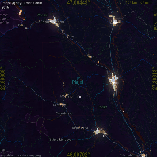
Analysis of Pârjol night lights 2016
Square area 10x10 km:
100  0%
0%
90-99 0%
80-89 0%
70-79 0%
60-69 0%
50-59 0%
40-49 0%
30-39 0%
20-29 0%
10-19 0%
0-9 100%
0%90-99
0%80-89
0%70-79
0%60-69
0%50-59
0%40-49
0%30-39
0%20-29
0%10-19
0%0-9
100%Square area 50x50 km:
100 0.37%
90-99 0.46%
80-89 0.26%
70-79 0.13%
60-69 0.08%
50-59 0.2%
40-49 0.25%
30-39 0.26%
20-29 0.42%
10-19 1.44%
0-9 96.12%
0.37%90-99
0.46%80-89
0.26%70-79
0.13%60-69
0.08%50-59
0.2%40-49
0.25%30-39
0.26%20-29
0.42%10-19
1.44%0-9
96.12%Clear (daylight) street map image can be seen on geolist.org.
Map coordinates:
47° 3' 51.9" North, 25° 53' 48.8" East
46° 34' 60" North, 26° 36' 0" East
46° 5' 52.5" North, 27° 18' 11.3" East
Some cities around Pârjol sort by population:
• Moineşti
14.7 km =9.1 mi,  215°
215°
• Buhuşi
16.7 km =10.4 mi,  27°
27°
• Balcani
6.7 km =4.2 mi,  325°
325°
• Poduri
13.9 km =8.6 mi,  201°
201°
• Blăgeşti
11.8 km =7.3 mi,  18°
18°
• Bereşti-Tazlău
13.9 km =8.6 mi,  158°
158°
• Rediu
19.4 km =12.1 mi,  351°
351°
• Zemeş
14 km =8.7 mi,  270°
270°
670706 (p: 6,688)
Sources (retrieved 2019-11-25):
» Earth at Night: Flat Maps 2012, 2016