Mătăsaru night lights from space
Night Light of Mătăsaru (Dâmboviţa) from space (Romania) Src. Average luminocity for 10x10km area is 1.6485% and for 50x50km: 2.5534%.
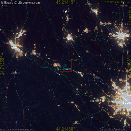
Analysis of Mătăsaru night lights 2016
Square area 10x10 km:
 0%
0%90-99
0%80-89
0%70-79
0%60-69
0.61%50-59
1.21%40-49
0%30-39
0%20-29
0.61%10-19
0%0-9
97.58%Square area 50x50 km:
0.29%90-99
0.28%80-89
0.18%70-79
0.23%60-69
0.42%50-59
0.42%40-49
0.51%30-39
0.41%20-29
0.66%10-19
1.4%0-9
95.19%Clear (daylight) street map image can be seen on geolist.org.
Map coordinates:
45° 12' 50.9" North, 24° 42' 48.8" East
44° 43' 0" North, 25° 25' 0" East
44° 12' 53.6" North, 26° 7' 11.3" East
Some cities around Mătăsaru sort by population:
• Găeşti
7.9 km =4.9 mi,  270°
270°
• Titu
11.8 km =7.3 mi,  128°
128°
• Văcăreşti
15.7 km =9.8 mi,  19°
19°
• Dragodana
5.6 km =3.5 mi,  289°
289°
• Vişina
16.2 km =10.1 mi,  203°
203°
• Lucieni
14.9 km =9.3 mi,  5°
5°
• Petreşti
9.9 km =6.2 mi,  221°
221°
• Gura Şuţii
8.7 km =5.4 mi,  64°
64°
673691 (p: 5,722)
Sources (retrieved 2019-11-25):
» Earth at Night: Flat Maps 2012, 2016