Titu night lights from space
Night Light of Titu (Dâmboviţa) from space (Romania) Src. Average luminocity for 10x10km area is 6.4833% and for 50x50km: 2.6344%.
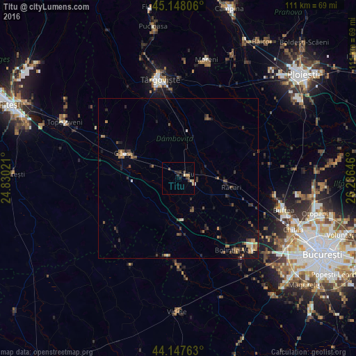
Analysis of Titu night lights 2016
Square area 10x10 km:
 0%
0%90-99
0.76%80-89
1.67%70-79
0.61%60-69
0.76%50-59
1.06%40-49
0.61%30-39
2.42%20-29
2.42%10-19
0%0-9
89.7%Square area 50x50 km:
0.1%90-99
0.24%80-89
0.21%70-79
0.29%60-69
0.56%50-59
0.39%40-49
0.67%30-39
0.59%20-29
0.72%10-19
1.43%0-9
94.79%Clear (daylight) street map image can be seen on geolist.org.
Map coordinates:
45° 8' 53" North, 24° 49' 48.8" East
44° 39' 0" North, 25° 31' 60" East
44° 8' 51.5" North, 26° 14' 11.3" East
Some cities around Titu sort by population:
• Potlogi
11.8 km =7.3 mi,  160°
160°
• Corbii Mari
11.4 km =7.1 mi,  193°
193°
• Răcari
15.9 km =9.9 mi,  96°
96°
• Petreşti
15.8 km =9.8 mi,  270°
270°
• Mătăsaru
11.8 km =7.3 mi,  308°
308°
• Lunguleţu
9.9 km =6.2 mi,  111°
111°
• Gura Şuţii
11.2 km =7 mi,  353°
353°
• Odobeşti
4.5 km =2.8 mi,  144°
144°
664891 (p: 10,081)
Sources (retrieved 2019-11-25):
» Earth at Night: Flat Maps 2012, 2016