Găeşti night lights from space
Night Light of Găeşti (Dâmboviţa) from space (Romania) Src. Average luminocity for 10x10km area is 10.6409% and for 50x50km: 2.7633%.
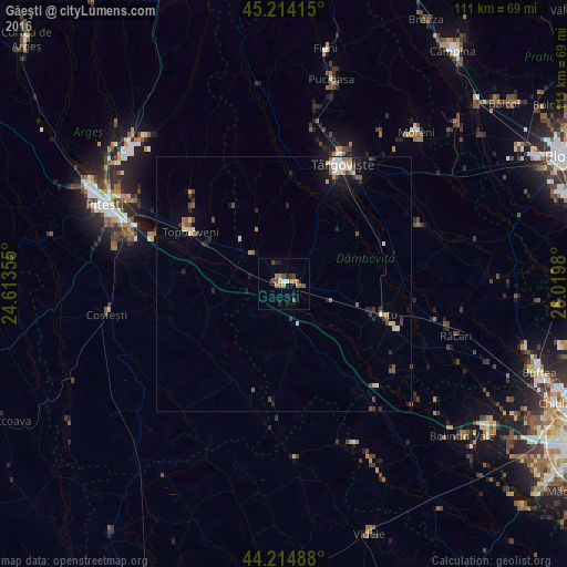
Analysis of Găeşti night lights 2016
Square area 10x10 km:
 0.45%
0.45%90-99
0.76%80-89
0%70-79
2.12%60-69
2.88%50-59
3.48%40-49
2.42%30-39
0.61%20-29
1.36%10-19
1.82%0-9
84.09%Square area 50x50 km:
0.34%90-99
0.3%80-89
0.23%70-79
0.29%60-69
0.43%50-59
0.48%40-49
0.47%30-39
0.44%20-29
0.56%10-19
1.33%0-9
95.14%Clear (daylight) street map image can be seen on geolist.org.
Map coordinates:
45° 12' 50.9" North, 24° 36' 48.8" East
44° 43' 0" North, 25° 19' 0" East
44° 12' 53.6" North, 26° 1' 11.3" East
Some cities around Găeşti sort by population:
• Dragodana
3.2 km =2 mi,  54°
54°
• Vişina
14.9 km =9.3 mi,  174°
174°
• Lucieni
17.5 km =10.9 mi,  31°
31°
• Petreşti
7.5 km =4.7 mi, 169°
• Leordeni
17.4 km =10.8 mi,  295°
295°
• Mătăsaru
7.9 km =4.9 mi,  90°
90°
• Gura Şuţii
16.2 km =10.1 mi,  76°
76°
• Ludeşti
17.9 km =11.1 mi,  338°
338°
677742 (p: 15,037)
Sources (retrieved 2019-11-25):
» Earth at Night: Flat Maps 2012, 2016