Văcăreşti night lights from space
Night Light of Văcăreşti (Dâmboviţa) from space (Romania) Src. Average luminocity for 10x10km area is 2.7365% and for 50x50km: 3.4725%.
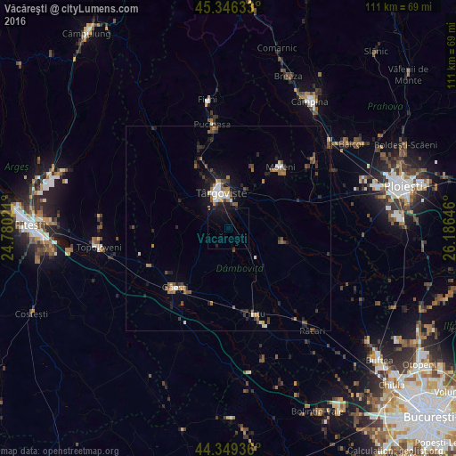
Analysis of Văcăreşti night lights 2016
Square area 10x10 km:
 0%
0%90-99
0%80-89
0%70-79
0.32%60-69
0%50-59
0%40-49
0%30-39
0%20-29
1.27%10-19
6.98%0-9
91.43%Square area 50x50 km:
0.34%90-99
0.34%80-89
0.21%70-79
0.31%60-69
0.6%50-59
0.6%40-49
0.73%30-39
0.57%20-29
0.95%10-19
2.21%0-9
93.12%Clear (daylight) street map image can be seen on geolist.org.
Map coordinates:
45° 20' 46.8" North, 24° 46' 48.8" East
44° 51' 0" North, 25° 28' 60" East
44° 20' 57.7" North, 26° 11' 11.3" East
Some cities around Văcăreşti sort by population:
• Târgovişte
8.6 km =5.3 mi,  345°
345°
• Răzvad
10.1 km =6.3 mi,  23°
23°
• Băleni Sârbi
12.4 km =7.7 mi,  107°
107°
• Bucşani
13.3 km =8.3 mi,  81°
81°
• Lucieni
3.9 km =2.4 mi,  270°
270°
• Aninoasa
13.6 km =8.5 mi,  343°
343°
• Comişani
8.7 km =5.4 mi,  64°
64°
• Gura Şuţii
11.4 km =7.1 mi,  166°
166°
664041 (p: 7,812)
Sources (retrieved 2019-11-25):
» Earth at Night: Flat Maps 2012, 2016