Lucieni night lights from space
Night Light of Lucieni (Dâmboviţa) from space (Romania) Src. Average luminocity for 10x10km area is 2.5587% and for 50x50km: 3.3264%.
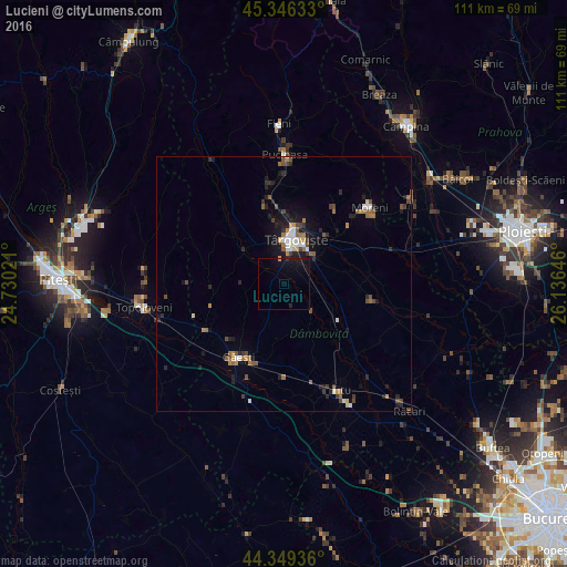
Analysis of Lucieni night lights 2016
Square area 10x10 km:
 0%
0%90-99
0%80-89
0%70-79
0.32%60-69
0%50-59
0%40-49
0%30-39
0%20-29
0.95%10-19
6.83%0-9
91.9%Square area 50x50 km:
0.34%90-99
0.33%80-89
0.18%70-79
0.31%60-69
0.6%50-59
0.56%40-49
0.65%30-39
0.49%20-29
0.95%10-19
2.2%0-9
93.37%Clear (daylight) street map image can be seen on geolist.org.
Map coordinates:
45° 20' 46.8" North, 24° 43' 48.8" East
44° 51' 0" North, 25° 25' 60" East
44° 20' 57.7" North, 26° 8' 11.3" East
Some cities around Lucieni sort by population:
• Târgovişte
8.6 km =5.3 mi,  12°
12°
• Răzvad
12.2 km =7.6 mi,  40°
40°
• Dragomireşti
10.8 km =6.7 mi,  313°
313°
• Văcăreşti
3.9 km =2.4 mi,  90°
90°
• Dragodana
14.5 km =9 mi,  206°
206°
• Aninoasa
13 km =8.1 mi,  0°
0°
• Comişani
12.4 km =7.7 mi,  72°
72°
• Gura Şuţii
12.9 km =8 mi,  149°
149°
674560 (p: 6,286)
Sources (retrieved 2019-11-25):
» Earth at Night: Flat Maps 2012, 2016