Mânăstirea night lights from space
Night Light of Mânăstirea (Călăraşi) from space (Romania) Src. Average luminocity for 10x10km area is 0.7455% and for 50x50km: 1.0699%.
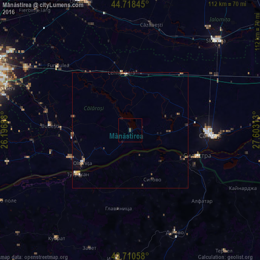
Analysis of Mânăstirea night lights 2016
Square area 10x10 km:
 0%
0%90-99
0%80-89
0%70-79
0%60-69
0%50-59
0%40-49
0.91%30-39
0.3%20-29
0.15%10-19
0.76%0-9
97.88%Square area 50x50 km:
0.05%90-99
0.1%80-89
0.05%70-79
0.18%60-69
0.2%50-59
0.14%40-49
0.32%30-39
0.23%20-29
0.33%10-19
0.25%0-9
98.15%Clear (daylight) street map image can be seen on geolist.org.
Map coordinates:
44° 43' 6.4" North, 26° 11' 48.8" East
44° 13' 0" North, 26° 54' 0" East
43° 42' 38.1" North, 27° 36' 11.3" East
Some cities around Mânăstirea sort by population:
• Olteniţa
25.9 km =16.1 mi,  235°
235°
• Tutrakan, BG
29.6 km =18.4 mi,  230°
230°
• Chirnogi
28.8 km =17.9 mi,  247°
247°
• Dor Mărunt
26 km =16.2 mi,  2°
2°
• Lehliu-Gară
24.4 km =15.2 mi,  350°
350°
• Ulmeni
16.4 km =10.2 mi, 243°
• Grădiştea
25.3 km =15.7 mi,  85°
85°
• Curcani
25.3 km =15.7 mi,  265°
265°
673275 (p: 6,123)
Sources (retrieved 2019-11-25):
» Earth at Night: Flat Maps 2012, 2016