Poiana Câmpina night lights from space
Night Light of Poiana Câmpina (Prahova) from space (Romania) Src. Average luminocity for 10x10km area is 12.4924% and for 50x50km: 5.7652%.
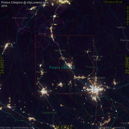
Analysis of Poiana Câmpina night lights 2016
Square area 10x10 km:
 1.97%
1.97%90-99
1.67%80-89
0%70-79
1.82%60-69
2.42%50-59
0.3%40-49
3.64%30-39
1.06%20-29
2.73%10-19
8.48%0-9
75.91%Square area 50x50 km:
0.82%90-99
0.82%80-89
0.37%70-79
0.4%60-69
0.7%50-59
0.75%40-49
1.36%30-39
1.01%20-29
1.66%10-19
3.31%0-9
88.79%Clear (daylight) street map image can be seen on geolist.org.
Map coordinates:
45° 37' 37.9" North, 24° 58' 48.8" East
45° 7' 60" North, 25° 40' 60" East
44° 38' 6.5" North, 26° 23' 11.3" East
Some cities around Poiana Câmpina sort by population:
• Câmpina
4.1 km =2.5 mi,  101°
101°
• Breaza
5.7 km =3.5 mi,  346°
346°
• Breaza de Sus
7.6 km =4.7 mi,  343°
343°
• Brebu Mânăstirei
8.6 km =5.3 mi,  49°
49°
• Doftana
9.3 km =5.8 mi,  78°
78°
• Măgureni
8.4 km =5.2 mi,  152°
152°
• Telega
7.8 km =4.8 mi,  90°
90°
• Băneşti
7.5 km =4.7 mi,  119°
119°
670098 (p: 5,254)
Sources (retrieved 2019-11-25):
» Earth at Night: Flat Maps 2012, 2016