Gătaia night lights from space
Night Light of Gătaia (Timiş) from space (Romania) Src. Average luminocity for 10x10km area is 4.5238% and for 50x50km: 0.9372%.
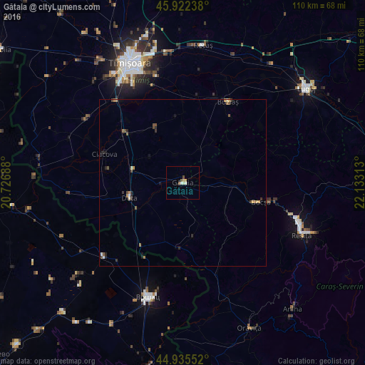
Analysis of Gătaia night lights 2016
Square area 10x10 km:
100  0.48%
0.48%
90-99 1.11%
80-89 0.32%
70-79 1.27%
60-69 0.16%
50-59 1.11%
40-49 0.63%
30-39 0%
20-29 0%
10-19 0%
0-9 94.92%
0.48%90-99
1.11%80-89
0.32%70-79
1.27%60-69
0.16%50-59
1.11%40-49
0.63%30-39
0%20-29
0%10-19
0%0-9
94.92%Square area 50x50 km:
100 0.04%
90-99 0.13%
80-89 0.08%
70-79 0.17%
60-69 0.14%
50-59 0.25%
40-49 0.19%
30-39 0.11%
20-29 0.27%
10-19 0.18%
0-9 98.45%
0.04%90-99
0.13%80-89
0.08%70-79
0.17%60-69
0.14%50-59
0.25%40-49
0.19%30-39
0.11%20-29
0.27%10-19
0.18%0-9
98.45%Clear (daylight) street map image can be seen on geolist.org.
Map coordinates:
45° 55' 20.6" North, 20° 43' 36.8" East
45° 25' 52" North, 21° 25' 48" East
44° 56' 7.9" North, 22° 7' 59.3" East
Some cities around Gătaia sort by population:
• Timişoara
39.2 km =24.4 mi,  336°
336°
• Reşiţa
38.7 km =24 mi,  111°
111°
• Vršac, RS
36.3 km =22.6 mi,  195°
195°
• Bocşa
22.7 km =14.1 mi, 106°
• Buziaş
27.8 km =17.3 mi,  29°
29°
• Ciacova
25 km =15.5 mi,  290°
290°
• Deta
16.7 km =10.4 mi,  253°
253°
• Jebel
21.8 km =13.5 mi,  309°
309°
677581 (p: 8,002)
Sources (retrieved 2019-11-25):
» Earth at Night: Flat Maps 2012, 2016