Frumuşani night lights from space
Night Light of Frumuşani (Călăraşi) from space (Romania) Src. Average luminocity for 10x10km area is 1.9591% and for 50x50km: 16.9413%.
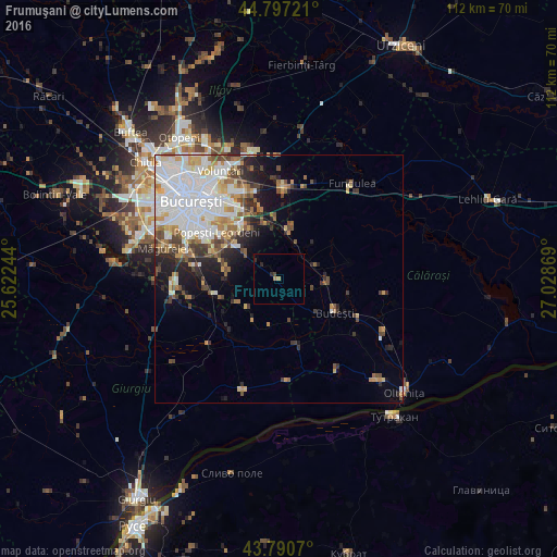
Analysis of Frumuşani night lights 2016
Square area 10x10 km:
100  0%
0%
90-99 0%
80-89 0%
70-79 0%
60-69 1.21%
50-59 0%
40-49 0.15%
30-39 0.61%
20-29 1.67%
10-19 0%
0-9 96.36%
0%90-99
0%80-89
0%70-79
0%60-69
1.21%50-59
0%40-49
0.15%30-39
0.61%20-29
1.67%10-19
0%0-9
96.36%Square area 50x50 km:
100 5.25%
90-99 3.78%
80-89 1.38%
70-79 1.83%
60-69 1.86%
50-59 1.6%
40-49 2.24%
30-39 1.55%
20-29 2.78%
10-19 4.32%
0-9 73.42%
5.25%90-99
3.78%80-89
1.38%70-79
1.83%60-69
1.86%50-59
1.6%40-49
2.24%30-39
1.55%20-29
2.78%10-19
4.32%0-9
73.42%Clear (daylight) street map image can be seen on geolist.org.
Map coordinates:
44° 47' 50" North, 25° 37' 20.8" East
44° 17' 46" North, 26° 19' 32" East
43° 47' 26.5" North, 27° 1' 43.3" East
Some cities around Frumuşani sort by population:
• Budeşti
13.1 km =8.1 mi,  121°
121°
• Cernica
13.8 km =8.6 mi,  345°
345°
• Hotarele
14.2 km =8.8 mi,  165°
165°
• Vidra
13 km =8.1 mi,  252°
252°
• Vasilaţi
9.7 km =6 mi,  95°
95°
• Glina
11.4 km =7.1 mi,  328°
328°
• Vărăşti
8.9 km =5.5 mi,  223°
223°
• Fundeni
9.9 km =6.2 mi,  11°
11°
677880 (p: 5,111)
Sources (retrieved 2019-11-25):
» Earth at Night: Flat Maps 2012, 2016