Vasilaţi night lights from space
Night Light of Vasilaţi (Călăraşi) from space (Romania) Src. Average luminocity for 10x10km area is 4.0348% and for 50x50km: 8.55%.
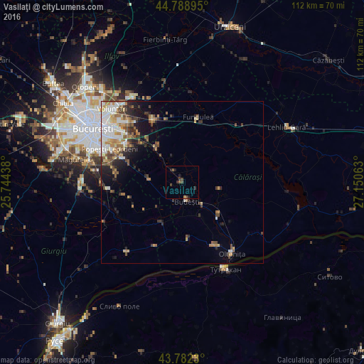
Analysis of Vasilaţi night lights 2016
Square area 10x10 km:
 0%
0%90-99
0%80-89
0%70-79
0.61%60-69
0%50-59
1.67%40-49
1.97%30-39
1.82%20-29
2.42%10-19
0%0-9
91.52%Square area 50x50 km:
1.56%90-99
1.49%80-89
0.94%70-79
1.11%60-69
1.36%50-59
1.03%40-49
1.54%30-39
1.03%20-29
1.89%10-19
3.04%0-9
85.01%Clear (daylight) street map image can be seen on geolist.org.
Map coordinates:
44° 47' 20.2" North, 25° 44' 39.8" East
44° 17' 16" North, 26° 26' 51" East
43° 46' 56.3" North, 27° 9' 2.3" East
Some cities around Vasilaţi sort by population:
• Budeşti
6.1 km =3.8 mi,  166°
166°
• Hotarele
14.2 km =8.8 mi,  205°
205°
• Glina
19 km =11.8 mi,  304°
304°
• Vărăşti
16.8 km =10.4 mi,  250°
250°
• Fundeni
13.2 km =8.2 mi,  323°
323°
• Curcani
14.6 km =9.1 mi,  132°
132°
• Frumuşani
9.7 km =6 mi,  275°
275°
• Radovanu
11.2 km =7 mi,  150°
150°
663128 (p: 7,840)
Sources (retrieved 2019-11-25):
» Earth at Night: Flat Maps 2012, 2016