Cernica night lights from space
Night Light of Cernica (Ilfov) from space (Romania) Src. Average luminocity for 10x10km area is 33.9571% and for 50x50km: 23.2552%.
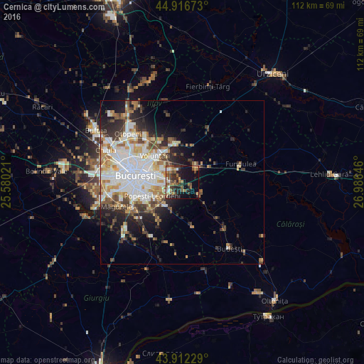
Analysis of Cernica night lights 2016
Square area 10x10 km:
 1.9%
1.9%90-99
3.65%80-89
4.13%70-79
4.44%60-69
7.3%50-59
7.94%40-49
7.46%30-39
6.35%20-29
12.38%10-19
23.49%0-9
20.95%Square area 50x50 km:
6.23%90-99
5.25%80-89
2.2%70-79
2.61%60-69
2.97%50-59
2.21%40-49
2.95%30-39
2.51%20-29
5%10-19
6.74%0-9
61.33%Clear (daylight) street map image can be seen on geolist.org.
Map coordinates:
44° 55' 0.2" North, 25° 34' 48.8" East
44° 25' 0" North, 26° 16' 60" East
43° 54' 44.2" North, 26° 59' 11.3" East
Some cities around Cernica sort by population:
• Sector 3
9.1 km =5.7 mi,  274°
274°
• Pantelimon
7.6 km =4.7 mi,  299°
299°
• Popeşti-Leordeni
10 km =6.2 mi,  248°
248°
• Brăneşti
5.4 km =3.4 mi,  46°
46°
• Glina
4.6 km =2.9 mi,  215°
215°
• Afumaţi
11.2 km =7 mi,  353°
353°
• Dobroeşti
8.8 km =5.5 mi, 295°
• Fundeni
6.5 km =4 mi,  124°
124°
682301 (p: 9,530)
Sources (retrieved 2019-11-25):
» Earth at Night: Flat Maps 2012, 2016