Bragadiru night lights from space
Night Light of Bragadiru (Ilfov) from space (Romania) Src. Average luminocity for 10x10km area is 55.6159% and for 50x50km: 25.9339%.
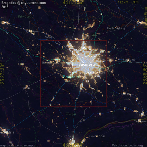
Analysis of Bragadiru night lights 2016
Square area 10x10 km:
 7.78%
7.78%90-99
10.32%80-89
8.1%70-79
8.89%60-69
6.98%50-59
14.13%40-49
10.79%30-39
4.44%20-29
17.62%10-19
10.95%0-9
0%Square area 50x50 km:
6.59%90-99
5.76%80-89
2.48%70-79
2.77%60-69
2.95%50-59
2.91%40-49
3.62%30-39
3.04%20-29
5.97%10-19
9.38%0-9
54.53%Clear (daylight) street map image can be seen on geolist.org.
Map coordinates:
44° 52' 17.6" North, 25° 16' 27.8" East
44° 22' 16" North, 25° 58' 39" East
43° 51' 58.8" North, 26° 40' 50.3" East
Some cities around Bragadiru sort by population:
• Sector 6
7.8 km =4.8 mi,  23°
23°
• Sector 5
7.7 km =4.8 mi,  75°
75°
• Jilava
9 km =5.6 mi,  117°
117°
• Măgurele
5 km =3.1 mi, 117°
• Mihăileşti
7.4 km =4.6 mi,  228°
228°
• Domneşti-Sârbi
5 km =3.1 mi,  285°
285°
• Domnești
5.8 km =3.6 mi,  302°
302°
• Cornetu
4.4 km =2.7 mi,  221°
221°
683914 (p: 8,274)
Sources (retrieved 2019-11-25):
» Earth at Night: Flat Maps 2012, 2016