Păuleşti night lights from space
Night Light of Păuleşti (Prahova) from space (Romania) Src. Average luminocity for 10x10km area is 31.8889% and for 50x50km: 7.5334%.
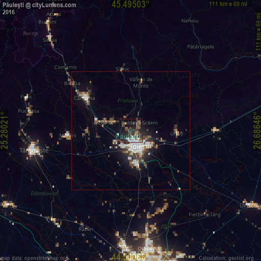
Analysis of Păuleşti night lights 2016
Square area 10x10 km:
 4.29%
4.29%90-99
3.97%80-89
0.48%70-79
1.43%60-69
2.38%50-59
8.89%40-49
8.89%30-39
10.48%20-29
16.19%10-19
23.81%0-9
19.21%Square area 50x50 km:
1.15%90-99
1.26%80-89
0.38%70-79
0.43%60-69
0.89%50-59
1.03%40-49
1.79%30-39
1.65%20-29
2.44%10-19
4.36%0-9
84.63%Clear (daylight) street map image can be seen on geolist.org.
Map coordinates:
45° 29' 42.1" North, 25° 16' 48.8" East
45° 0' 0" North, 25° 58' 60" East
44° 30' 2.4" North, 26° 41' 11.3" East
Some cities around Păuleşti sort by population:
• Ploieşti
6.1 km =3.8 mi,  154°
154°
• Băicoi
11.1 km =6.9 mi,  289°
289°
• Boldeşti-Scăeni
5.4 km =3.4 mi,  46°
46°
• Bucov
8.7 km =5.4 mi,  115°
115°
• Ariceştii-Rahtivani
13 km =8.1 mi,  244°
244°
• Plopeni
6 km =3.7 mi,  335°
335°
• Blejoi
2.6 km =1.6 mi,  90°
90°
• Berceni
12.8 km =8 mi,  125°
125°
671228 (p: 5,069)
Sources (retrieved 2019-11-25):
» Earth at Night: Flat Maps 2012, 2016