Gura Viţioarei night lights from space
Night Light of Gura Viţioarei (Prahova) from space (Romania) Src. Average luminocity for 10x10km area is 1.0364% and for 50x50km: 5.555%.
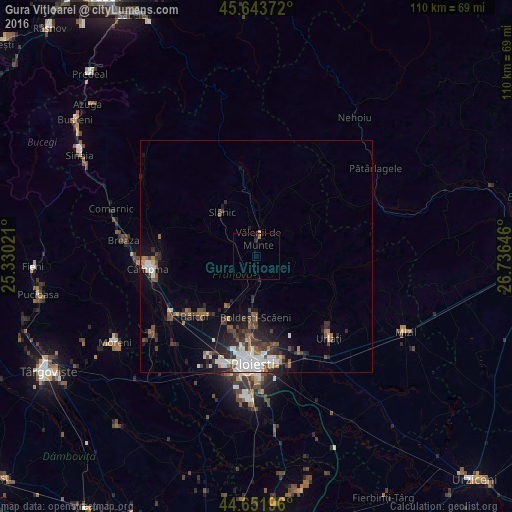
Analysis of Gura Viţioarei night lights 2016
Square area 10x10 km:
 0%
0%90-99
0%80-89
0%70-79
0.3%60-69
0.61%50-59
0%40-49
0%30-39
0%20-29
0.91%10-19
0.61%0-9
97.58%Square area 50x50 km:
0.99%90-99
0.98%80-89
0.27%70-79
0.31%60-69
0.66%50-59
0.76%40-49
1.25%30-39
1.08%20-29
1.75%10-19
2.75%0-9
89.19%Clear (daylight) street map image can be seen on geolist.org.
Map coordinates:
45° 38' 37.4" North, 25° 19' 48.8" East
45° 9' 0" North, 26° 1' 60" East
44° 39' 7.1" North, 26° 44' 11.3" East
Some cities around Gura Viţioarei sort by population:
• Vălenii de Munte
3.7 km =2.3 mi,  0°
0°
• Boldeşti-Scăeni
13 km =8.1 mi,  180°
180°
• Plopeni
12.9 km =8 mi,  209°
209°
• Blejoi
16.7 km =10.4 mi, 184°
• Vărbilău
7.5 km =4.7 mi,  299°
299°
• Slănic
13.6 km =8.5 mi,  324°
324°
• Scorţeni
15.4 km =9.6 mi,  248°
248°
• Drajna de Jos
7.5 km =4.7 mi,  9°
9°
676455 (p: 5,947)
Sources (retrieved 2019-11-25):
» Earth at Night: Flat Maps 2012, 2016