Valadares night lights from space
Night Light of Valadares (Porto) from space (Portugal) Src. Average luminocity for 10x10km area is 6.9464% and for 50x50km: 19.5655%.
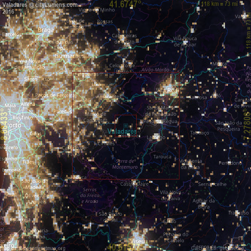
Analysis of Valadares night lights 2016
Square area 10x10 km:
 0%
0%90-99
1.79%80-89
1.46%70-79
0.97%60-69
0%50-59
0.65%40-49
0.65%30-39
0%20-29
3.25%10-19
0%0-9
91.23%Square area 50x50 km:
0.86%90-99
2.28%80-89
2.38%70-79
2.53%60-69
3.7%50-59
4.83%40-49
3.86%30-39
4.3%20-29
6.99%10-19
10.72%0-9
57.57%Clear (daylight) street map image can be seen on geolist.org.
Map coordinates:
41° 40' 28.9" North, 8° 41' 3.6" West
41° 8' 50.5" North, 7° 58' 52.3" West
40° 36' 56.8" North, 7° 16' 41.1" West
Some cities around Valadares sort by population:
• Baião
4.8 km =3 mi,  290°
290°
• Vila Real
26.1 km =16.2 mi,  49°
49°
• Perafita
23.2 km =14.4 mi,  279°
279°
• Lamego
15.4 km =9.6 mi,  111°
111°
• Marco de Canavezes
14.6 km =9.1 mi, 286°
• Alpendurada
23.1 km =14.4 mi,  253°
253°
• Amarante
16.3 km =10.1 mi,  328°
328°
• Peso da Régua
16.2 km =10.1 mi,  83°
83°
2733262 (p: 9,255)
Sources (retrieved 2019-11-25):
» Earth at Night: Flat Maps 2012, 2016