Alpendurada night lights from space
Night Light of Alpendurada (Porto) from space (Portugal) Src. Average luminocity for 10x10km area is 48.4416% and for 50x50km: 36.4055%.
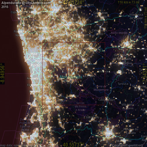
Analysis of Alpendurada night lights 2016
Square area 10x10 km:
 1.79%
1.79%90-99
4.06%80-89
5.52%70-79
8.93%60-69
12.01%50-59
15.75%40-49
15.1%30-39
6.82%20-29
18.51%10-19
11.04%0-9
0.49%Square area 50x50 km:
3.68%90-99
6.08%80-89
4.84%70-79
7.04%60-69
8.17%50-59
6.44%40-49
6.33%30-39
6.04%20-29
7.37%10-19
8.85%0-9
35.15%Clear (daylight) street map image can be seen on geolist.org.
Map coordinates:
41° 37' 2.1" North, 8° 56' 58.4" West
41° 5' 22" North, 8° 14' 47.1" West
40° 33' 26.5" North, 7° 32' 35.9" West
Some cities around Alpendurada sort by population:
• Paredes
14.7 km =9.1 mi,  330°
330°
• Perafita
10.4 km =6.5 mi,  356°
356°
• Moreira
12.5 km =7.8 mi,  252°
252°
• Melres
13.1 km =8.1 mi,  260°
260°
• Madalena
15.9 km =9.9 mi, 332°
• Marco de Canavezes
13.3 km =8.3 mi,  37°
37°
• Castelões de Cepeda
14.6 km =9.1 mi, 329°
• Penafiel
13.6 km =8.5 mi,  347°
347°
2743038 (p: 8,485)
Sources (retrieved 2019-11-25):
» Earth at Night: Flat Maps 2012, 2016