Perafita night lights from space
Night Light of Perafita (Porto) from space (Portugal) Src. Average luminocity for 10x10km area is 50.8782% and for 50x50km: 43.4359%.
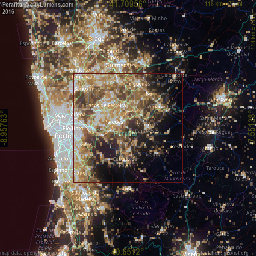
Analysis of Perafita night lights 2016
Square area 10x10 km:
 3.57%
3.57%90-99
6.66%80-89
5.03%70-79
8.6%60-69
11.53%50-59
10.06%40-49
14.29%30-39
14.61%20-29
22.4%10-19
3.25%0-9
0%Square area 50x50 km:
4.4%90-99
7.46%80-89
6.2%70-79
8.54%60-69
9.85%50-59
8.47%40-49
7.3%30-39
6.34%20-29
7.76%10-19
8.96%0-9
24.72%Clear (daylight) street map image can be seen on geolist.org.
Map coordinates:
41° 42' 34.4" North, 8° 57' 27.5" West
41° 10' 57.1" North, 8° 15' 16.2" West
40° 39' 4.3" North, 7° 33' 5" West
Some cities around Perafita sort by population:
• Paredes
6.9 km =4.3 mi,  291°
291°
• Rebordosa
13.5 km =8.4 mi, 289°
• Madalena
7.7 km =4.8 mi,  299°
299°
• Marco de Canavezes
8.9 km =5.5 mi,  89°
89°
• Alpendurada
10.4 km =6.5 mi,  176°
176°
• Castelões de Cepeda
7.1 km =4.4 mi, 288°
• Penafiel
3.7 km =2.3 mi,  320°
320°
• Freamunde
13.6 km =8.5 mi,  330°
330°
2736391 (p: 12,538)
Sources (retrieved 2019-11-25):
» Earth at Night: Flat Maps 2012, 2016