Vila Real night lights from space
Night Light of Vila Real from space (Portugal) Src. Average luminocity for 10x10km area is 51.5731% and for 50x50km: 10.7381%.
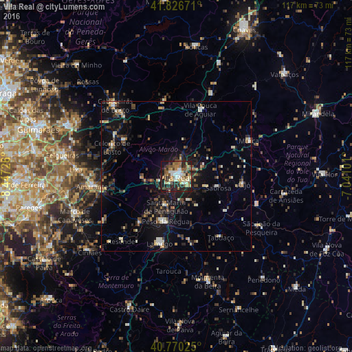
Analysis of Vila Real night lights 2016
Square area 10x10 km:
 6.33%
6.33%90-99
9.74%80-89
7.79%70-79
5.03%60-69
9.74%50-59
13.96%40-49
5.52%30-39
6.49%20-29
20.29%10-19
14.61%0-9
0.49%Square area 50x50 km:
0.62%90-99
1.61%80-89
1.3%70-79
0.77%60-69
1.23%50-59
1.79%40-49
1.57%30-39
1.85%20-29
3.9%10-19
9%0-9
76.37%Clear (daylight) street map image can be seen on geolist.org.
Map coordinates:
41° 49' 36.2" North, 8° 26' 50.1" West
41° 18' 2.2" North, 7° 44' 38.9" West
40° 46' 12.9" North, 7° 2' 27.6" West
Some cities around Vila Real sort by population:
• Alijó
22.7 km =14.1 mi,  96°
96°
• Lamego
23.3 km =14.5 mi,  193°
193°
• Valadares
26.1 km =16.2 mi,  229°
229°
• Mondim de Basto
21.5 km =13.4 mi,  305°
305°
• Sabrosa
14.5 km =9 mi, 104°
• Tabuaço
25.3 km =15.7 mi,  144°
144°
• Vilela
14.5 km =9 mi,  125°
125°
• Peso da Régua
15.7 km =9.8 mi, 193°
2732438 (p: 17,001)
Sources (retrieved 2019-11-25):
» Earth at Night: Flat Maps 2012, 2016