Póvoa de Lanhoso night lights from space
Night Light of Póvoa de Lanhoso (Braga) from space (Portugal) Src. Average luminocity for 10x10km area is 37.3344% and for 50x50km: 34.7914%.
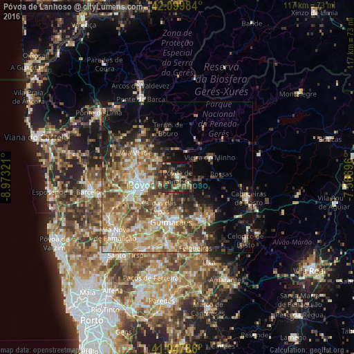
Analysis of Póvoa de Lanhoso night lights 2016
Square area 10x10 km:
 1.14%
1.14%90-99
1.95%80-89
3.41%70-79
4.38%60-69
10.39%50-59
7.95%40-49
8.6%30-39
10.71%20-29
26.79%10-19
22.08%0-9
2.6%Square area 50x50 km:
2.84%90-99
6.37%80-89
5.35%70-79
5.81%60-69
8.29%50-59
6.53%40-49
5.64%30-39
4.86%20-29
7.21%10-19
9.21%0-9
37.91%Clear (daylight) street map image can be seen on geolist.org.
Map coordinates:
42° 5' 59.4" North, 8° 58' 23.6" West
41° 34' 33.6" North, 8° 16' 12.3" West
41° 2' 52.3" North, 7° 34' 1.1" West
Some cities around Póvoa de Lanhoso sort by population:
• Braga
12.8 km =8 mi,  257°
257°
• Guimarães
14.8 km =9.2 mi,  188°
188°
• Real
14.5 km =9 mi, 262°
• Ponte
12.7 km =7.9 mi,  203°
203°
• Arcos
14 km =8.7 mi,  244°
244°
• Caldelas
14 km =8.7 mi,  318°
318°
• Caldas das Taipas
12.1 km =7.5 mi,  212°
212°
• Brito
15.1 km =9.4 mi, 210°
2735803 (p: 5,008)
Sources (retrieved 2019-11-25):
» Earth at Night: Flat Maps 2012, 2016