Louriçal night lights from space
Night Light of Louriçal (Leiria) from space (Portugal) Src. Average luminocity for 10x10km area is 17.1344% and for 50x50km: 17.0418%.
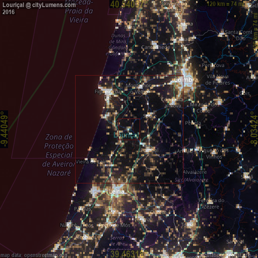
Analysis of Louriçal night lights 2016
Square area 10x10 km:
 0.17%
0.17%90-99
2.55%80-89
1.19%70-79
1.53%60-69
1.36%50-59
3.06%40-49
3.74%30-39
3.23%20-29
3.23%10-19
25.85%0-9
54.08%Square area 50x50 km:
1.2%90-99
2.02%80-89
1.09%70-79
1.72%60-69
2.19%50-59
2.88%40-49
2.66%30-39
3.73%20-29
7.28%10-19
19.95%0-9
55.28%Clear (daylight) street map image can be seen on geolist.org.
Map coordinates:
40° 32' 25.3" North, 9° 26' 25.8" West
40° 0' 14" North, 8° 44' 14.5" West
39° 27' 47.4" North, 8° 2' 3.3" West
Some cities around Louriçal sort by population:
• Figueira da Foz
19.5 km =12.1 mi,  327°
327°
• Pombal
13.4 km =8.3 mi,  136°
136°
• Condeixa-a-Nova
23.7 km =14.7 mi,  59°
59°
• Tavarede
20.3 km =12.6 mi, 333°
• Soure
11.3 km =7 mi, 56°
• Buarcos
21.6 km =13.4 mi, 326°
• Vieira de Leiria
22.4 km =13.9 mi,  228°
228°
• Monte Real
20 km =12.4 mi,  212°
212°
2266974 (p: 5,085)
Sources (retrieved 2019-11-25):
» Earth at Night: Flat Maps 2012, 2016