Lordelo night lights from space
Night Light of Lordelo (Porto) from space (Portugal) Src. Average luminocity for 10x10km area is 83.3425% and for 50x50km: 63.44%.
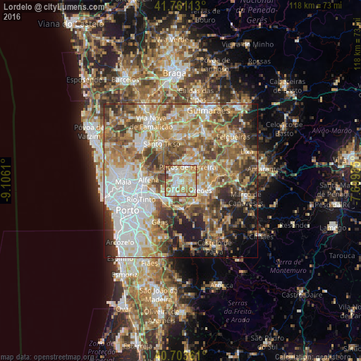
Analysis of Lordelo night lights 2016
Square area 10x10 km:
 14.61%
90-99
29.87%80-89
15.58%70-79
22.4%60-69
12.18%50-59
1.3%40-49
3.73%30-39
0.32%20-29
0%10-19
0%0-9
0%Square area 50x50 km:
14.11%90-99
12.51%80-89
8.2%70-79
10.64%60-69
12.35%50-59
10.06%40-49
8.47%30-39
7.21%20-29
6.99%10-19
6.85%0-9
2.61%Clear (daylight) street map image can be seen on geolist.org.
Map coordinates:
41° 45' 40.1" North, 9° 6' 22" West
41° 14' 4.2" North, 8° 24' 10.7" West
40° 42' 13" North, 7° 41' 59.5" West
Some cities around Lordelo sort by population:
• Paredes
6.8 km =4.2 mi,  118°
118°
• Rebordosa
1.2 km =0.7 mi,  194°
194°
• Madalena
6.1 km =3.8 mi,  109°
109°
• Campo
7.5 km =4.7 mi,  223°
223°
• Castelões de Cepeda
6.7 km =4.2 mi, 121°
• Paços de Ferreira
5.2 km =3.2 mi,  25°
25°
• Sobrado
5.1 km =3.2 mi,  238°
238°
• Gandra
4.5 km =2.8 mi,  214°
214°
2738224 (p: 10,035)
Sources (retrieved 2019-11-25):
» Earth at Night: Flat Maps 2012, 2016