Assafarge night lights from space
Night Light of Assafarge (Coimbra) from space (Portugal) Src. Average luminocity for 10x10km area is 58.8685% and for 50x50km: 16.9726%.
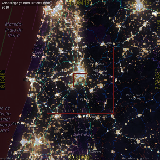
Analysis of Assafarge night lights 2016
Square area 10x10 km:
 10.88%
90-99
13.15%80-89
5.36%70-79
8.6%60-69
11.04%50-59
11.2%40-49
7.95%30-39
7.95%20-29
13.64%10-19
10.23%0-9
0%Square area 50x50 km:
1.9%90-99
2.25%80-89
1.46%70-79
1.53%60-69
1.99%50-59
2.41%40-49
2.54%30-39
3.68%20-29
6.03%10-19
13.87%0-9
62.34%Clear (daylight) street map image can be seen on geolist.org.
Map coordinates:
40° 41' 39.1" North, 9° 8' 5.3" West
40° 9' 32.2" North, 8° 25' 54" West
39° 37' 10.1" North, 7° 43' 42.8" West
Some cities around Assafarge sort by population:
• Coimbra
5.3 km =3.3 mi,  11°
11°
• Santo António dos Olivais
6.9 km =4.3 mi,  18°
18°
• Condeixa-a-Nova
7.6 km =4.7 mi,  227°
227°
• Lousã
16.2 km =10.1 mi,  106°
106°
• Santa Clara
4.6 km =2.9 mi,  350°
350°
• Soure
19.9 km =12.4 mi,  236°
236°
• Miranda do Corvo
11.2 km =7 mi,  130°
130°
• Poiares
15.9 km =9.9 mi,  68°
68°
2742649 (p: 5,302)
Sources (retrieved 2019-11-25):
» Earth at Night: Flat Maps 2012, 2016