Soure night lights from space
Night Light of Soure (Coimbra) from space (Portugal) Src. Average luminocity for 10x10km area is 16.5244% and for 50x50km: 20.6153%.
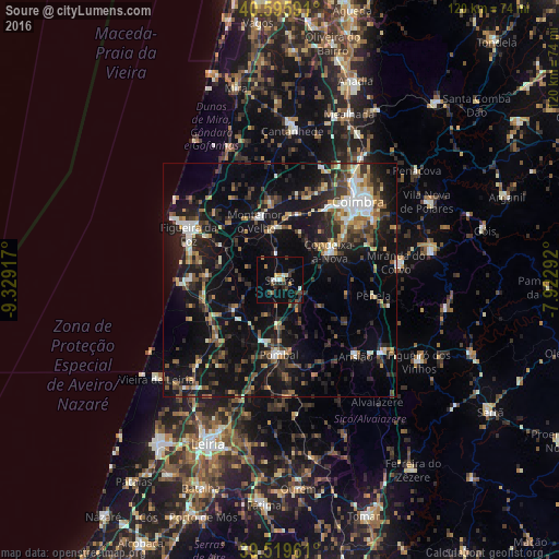
Analysis of Soure night lights 2016
Square area 10x10 km:
 1.14%
1.14%90-99
2.11%80-89
1.14%70-79
1.3%60-69
2.11%50-59
1.3%40-49
3.08%30-39
4.55%20-29
5.03%10-19
6.01%0-9
72.24%Square area 50x50 km:
2.07%90-99
2.76%80-89
1.7%70-79
2%60-69
2.61%50-59
3.11%40-49
3.07%30-39
4.17%20-29
7.49%10-19
21.12%0-9
49.91%Clear (daylight) street map image can be seen on geolist.org.
Map coordinates:
40° 35' 45.3" North, 9° 19' 45" West
40° 3' 35.6" North, 8° 37' 33.8" West
39° 31' 10.6" North, 7° 55' 22.5" West
Some cities around Soure sort by population:
• Coimbra
23.9 km =14.9 mi,  47°
47°
• Figueira da Foz
22.5 km =14 mi,  296°
296°
• Pombal
15.9 km =9.9 mi,  180°
180°
• Condeixa-a-Nova
12.4 km =7.7 mi,  61°
61°
• Santa Clara
22.2 km =13.8 mi, 45°
• Tavarede
22.1 km =13.7 mi, 302°
• Assafarge
19.9 km =12.4 mi, 56°
• Louriçal
11.3 km =7 mi,  236°
236°
2733851 (p: 8,416)
Sources (retrieved 2019-11-25):
» Earth at Night: Flat Maps 2012, 2016