Za‘tarah night lights from space
Night Light of Za‘tarah (West Bank) from space (Palestinian Territory) Src. Average luminocity for 10x10km area is 44.6886% and for 50x50km: 39.4215%.
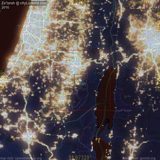
Analysis of Za‘tarah night lights 2016
Square area 10x10 km:
 4.95%
4.95%90-99
3.85%80-89
9.89%70-79
10.26%60-69
5.13%50-59
8.79%40-49
11.54%30-39
4.95%20-29
7.14%10-19
19.23%0-9
14.29%Square area 50x50 km:
7.26%90-99
7.05%80-89
6.93%70-79
8.09%60-69
3.86%50-59
6.23%40-49
6.66%30-39
5.43%20-29
5.36%10-19
7.48%0-9
35.65%Clear (daylight) street map image can be seen on geolist.org.
Map coordinates:
32° 16' 12.3" North, 34° 33' 12.6" East
31° 40' 25" North, 35° 15' 23.8" East
31° 4' 23.8" North, 35° 57' 35.1" East
Some cities around Za‘tarah sort by population:
• Bethlehem
6.1 km =3.8 mi,  304°
304°
• Bayt Jālā
8 km =5 mi,  305°
305°
• Bayt Sāḩūr
4.2 km =2.6 mi,  316°
316°
• Abū Dīs
9.9 km =6.2 mi,  2°
2°
• Al ‘Ubaydīyah
5.8 km =3.6 mi,  33°
33°
• Ad Dawḩah
7.8 km =4.8 mi,  291°
291°
• Al Khaḑir
8.8 km =5.5 mi,  284°
284°
• Jannātah
3.5 km =2.2 mi,  262°
262°
281240 (p: 6,210)
Sources (retrieved 2019-11-25):
» Earth at Night: Flat Maps 2012, 2016