‘Illār night lights from space
Night Light of ‘Illār (West Bank) from space (Palestinian Territory) Src. Average luminocity for 10x10km area is 48.2454% and for 50x50km: 60.8868%.
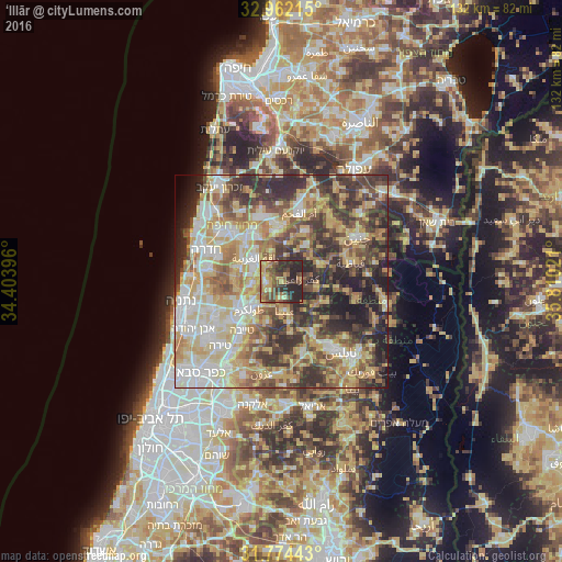
Analysis of ‘Illār night lights 2016
Square area 10x10 km:
 0.55%
0.55%90-99
2.2%80-89
8.06%70-79
13.37%60-69
8.06%50-59
10.07%40-49
16.12%30-39
10.07%20-29
29.49%10-19
2.01%0-9
0%Square area 50x50 km:
8.9%90-99
11.55%80-89
13.52%70-79
10.4%60-69
7.93%50-59
8.14%40-49
10.36%30-39
10.95%20-29
12.03%10-19
5.23%0-9
0.98%Clear (daylight) street map image can be seen on geolist.org.
Map coordinates:
32° 57' 43.7" North, 34° 24' 14.3" East
32° 22' 12.9" North, 35° 6' 25.5" East
31° 46' 27.9" North, 35° 48' 36.8" East
Some cities around ‘Illār sort by population:
• ‘Attīl
3.3 km =2.1 mi,  268°
268°
• Dayr al Ghuşūn
3.5 km =2.2 mi,  235°
235°
• Qaffīn
7.3 km =4.5 mi,  341°
341°
• Dhannābah
8.8 km =5.5 mi,  224°
224°
• Kafr Rā‘ī
4.5 km =2.8 mi,  84°
84°
• ‘Anabtā
7 km =4.3 mi,  172°
172°
• Bal‘ā
4.1 km =2.5 mi, 173°
• Sīlat az̧ Z̧ahr
9.2 km =5.7 mi,  128°
128°
283612 (p: 6,681)
Sources (retrieved 2019-11-25):
» Earth at Night: Flat Maps 2012, 2016