Jericho night lights from space
Night Light of Jericho (West Bank) from space (Palestinian Territory) Src. Average luminocity for 10x10km area is 44.9249% and for 50x50km: 31.1573%.
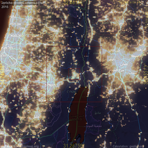
Analysis of Jericho night lights 2016
Square area 10x10 km:
 1.65%
1.65%90-99
7.69%80-89
10.81%70-79
11.36%60-69
6.23%50-59
2.75%40-49
5.49%30-39
4.58%20-29
19.6%10-19
27.29%0-9
2.56%Square area 50x50 km:
4.77%90-99
4.37%80-89
6.45%70-79
6.04%60-69
2.99%50-59
2.76%40-49
4.57%30-39
4.11%20-29
7.06%10-19
15.96%0-9
40.9%Clear (daylight) street map image can be seen on geolist.org.
Map coordinates:
32° 27' 42.8" North, 34° 44' 48.8" East
31° 52' 0" North, 35° 27' 0" East
31° 16' 3.3" North, 36° 9' 11.3" East
Some cities around Jericho sort by population:
• Ar Rām wa Ḑāḩiyat al Barīd
20.5 km =12.7 mi,  264°
264°
• Al ‘Ayzarīyah
20.1 km =12.5 mi,  238°
238°
• ‘Anātā
19.1 km =11.9 mi,  250°
250°
• Abū Dīs
21.3 km =13.2 mi, 236°
• Al Karāmah, JO
15.7 km =9.8 mi,  51°
51°
• Silwād
21.6 km =13.4 mi,  304°
304°
• Dayr Dibwān
18 km =11.2 mi,  285°
285°
• Ḩizmā
18 km =11.2 mi, 258°
284899 (p: 19,783)
Sources (retrieved 2019-11-25):
» Earth at Night: Flat Maps 2012, 2016