Ḩuwwārah night lights from space
Night Light of Ḩuwwārah (West Bank) from space (Palestinian Territory) Src. Average luminocity for 10x10km area is 60.3182% and for 50x50km: 42.4009%.
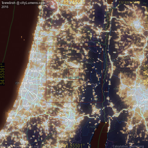
Analysis of Ḩuwwārah night lights 2016
Square area 10x10 km:
 1.57%
1.57%90-99
3.85%80-89
12.41%70-79
17.66%60-69
11.19%50-59
19.06%40-49
22.55%30-39
11.01%20-29
0.7%10-19
0%0-9
0%Square area 50x50 km:
2.97%90-99
4.1%80-89
8.58%70-79
9.77%60-69
6.42%50-59
8.27%40-49
10.68%30-39
9.27%20-29
9.82%10-19
7.5%0-9
22.62%Clear (daylight) street map image can be seen on geolist.org.
Map coordinates:
32° 44' 44.1" North, 34° 33' 13" East
32° 9' 8.1" North, 35° 15' 24.2" East
31° 33' 18" North, 35° 57' 35.5" East
Some cities around Ḩuwwārah sort by population:
• Nablus
7.7 km =4.8 mi,  358°
358°
• Ariel, IL
8.5 km =5.3 mi,  233°
233°
• Balāţah
7.2 km =4.5 mi,  22°
22°
• Bayt Fūrīk
7.9 km =4.9 mi,  69°
69°
• Baytā al Fawqā
3.1 km =1.9 mi,  110°
110°
• Qabalān
6.4 km =4 mi,  151°
151°
• Jammā‘īn
5.5 km =3.4 mi,  245°
245°
• ‘Awartā
2.7 km =1.7 mi, 68°
283636 (p: 5,633)
Sources (retrieved 2019-11-25):
» Earth at Night: Flat Maps 2012, 2016