Adjuntas night lights from space
Night Light of Adjuntas from space (Puerto Rico) Src. Average luminocity for 10x10km area is 7.71% and for 50x50km: 19.6631%.
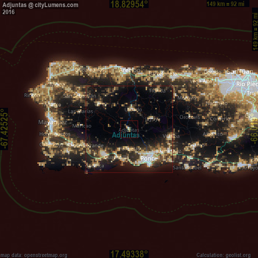
Analysis of Adjuntas night lights 2016
Square area 10x10 km:
 0.43%
0.43%90-99
0.43%80-89
0.87%70-79
1.73%60-69
1.73%50-59
1.08%40-49
0.65%30-39
1.52%20-29
1.08%10-19
3.03%0-9
87.45%Square area 50x50 km:
1.65%90-99
2.07%80-89
3.27%70-79
2.59%60-69
2.58%50-59
2.08%40-49
2.78%30-39
5.36%20-29
7.69%10-19
15.15%0-9
54.8%Clear (daylight) street map image can be seen on geolist.org.
Map coordinates:
18° 49' 46.3" North, 67° 25' 30.9" West
18° 9' 45.9" North, 66° 43' 19.6" West
17° 29' 36.2" North, 66° 1' 8.4" West
Some cities around Adjuntas sort by population:
• Ponce
19.9 km =12.4 mi,  148°
148°
• Yauco
19.6 km =12.2 mi,  223°
223°
• Utuado
11.7 km =7.3 mi,  11°
11°
• Lares
22 km =13.7 mi,  311°
311°
• Peñuelas
11.8 km =7.3 mi,  179°
179°
• Guayanilla
17.6 km =10.9 mi,  204°
204°
• Villalba
24.6 km =15.3 mi,  99°
99°
• Jayuya
15.1 km =9.4 mi,  65°
65°
4562485 (p: 5,080)
Sources (retrieved 2019-11-25):
» Earth at Night: Flat Maps 2012, 2016