Santa Isabel night lights from space
Night Light of Santa Isabel from space (Puerto Rico) Src. Average luminocity for 10x10km area is 25.9978% and for 50x50km: 16.346%.
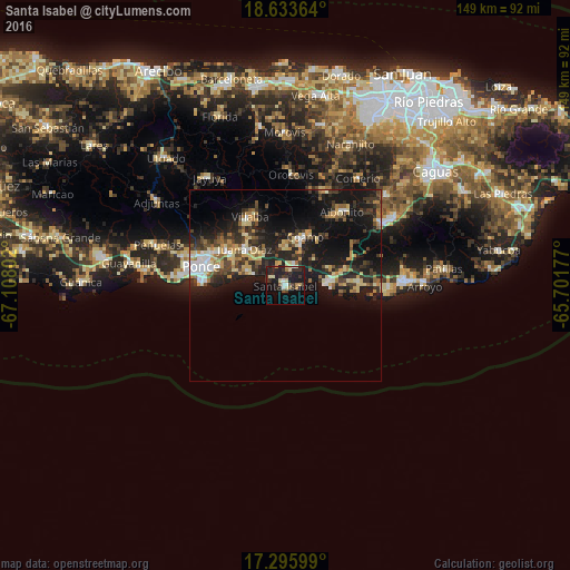
Analysis of Santa Isabel night lights 2016
Square area 10x10 km:
 1.73%
1.73%90-99
2.81%80-89
5.84%70-79
0.87%60-69
3.9%50-59
1.3%40-49
2.16%30-39
8.66%20-29
13.2%10-19
25.32%0-9
34.2%Square area 50x50 km:
1.49%90-99
1.76%80-89
2.82%70-79
1.96%60-69
2.21%50-59
1.53%40-49
2.55%30-39
4.24%20-29
5.81%10-19
16.01%0-9
59.62%Clear (daylight) street map image can be seen on geolist.org.
Map coordinates:
18° 38' 1.1" North, 67° 6' 28.9" West
17° 57' 57.9" North, 66° 24' 17.6" West
17° 17' 45.6" North, 65° 42' 6.4" West
Some cities around Santa Isabel sort by population:
• Ponce
23.7 km =14.7 mi,  281°
281°
• Coamo
13.6 km =8.5 mi,  21°
21°
• Juana Díaz
14.4 km =8.9 mi,  311°
311°
• Aibonito
24.3 km =15.1 mi,  37°
37°
• Salinas
11.4 km =7.1 mi,  83°
83°
• Coco
16.1 km =10 mi,  73°
73°
• Villalba
20.1 km =12.5 mi,  332°
332°
• Barranquitas
26.6 km =16.5 mi, 23°
4568212 (p: 7,260)
Sources (retrieved 2019-11-25):
» Earth at Night: Flat Maps 2012, 2016