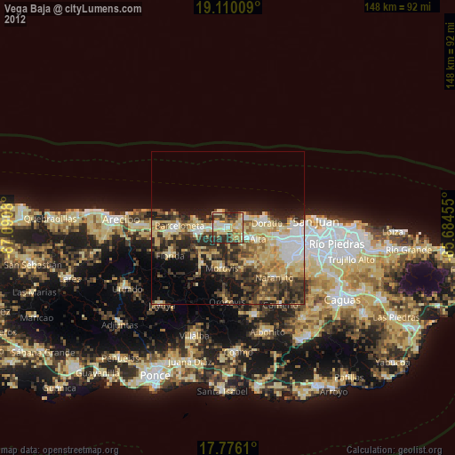
Vega Baja night lights from space
Night Light of Vega Baja from space (Puerto Rico) Src. Average luminocity for 10x10km area is 58.7314% and for 50x50km: 25.271%.

Analysis of Vega Baja night lights 2016
Square area 10x10 km:
100  5.99%
5.99%
90-99 6.61%
80-89 13.84%
70-79 14.26%
60-69 10.12%
50-59 3.1%
40-49 15.29%
30-39 14.46%
20-29 16.32%
10-19 0%
0-9 0%
5.99%90-99
6.61%80-89
13.84%70-79
14.26%60-69
10.12%50-59
3.1%40-49
15.29%30-39
14.46%20-29
16.32%10-19
0%0-9
0%Square area 50x50 km:
100 3.49%
90-99 3.08%
80-89 3.82%
70-79 3.44%
60-69 5.33%
50-59 2.93%
40-49 4.29%
30-39 5.5%
20-29 8.8%
10-19 10.12%
0-9 49.2%
3.49%90-99
3.08%80-89
3.82%70-79
3.44%60-69
5.33%50-59
2.93%40-49
4.29%30-39
5.5%20-29
8.8%10-19
10.12%0-9
49.2%Clear (daylight) street map image can be seen on geolist.org.
Map coordinates:
19° 6' 36.3" North, 67° 5' 26.9" West
18° 26' 39.8" North, 66° 23' 15.6" West
17° 46' 34" North, 65° 41' 4.4" West
Some cities around Vega Baja sort by population:
• Manatí
11.2 km =7 mi,  260°
260°
• Dorado
12.8 km =8 mi,  82°
82°
• Corozal
13.7 km =8.5 mi,  146°
146°
• Ceiba
3.9 km =2.4 mi,  86°
86°
• San Antonio
9 km =5.6 mi, 86°
• Ciales
14.8 km =9.2 mi,  215°
215°
• Morovis
13.3 km =8.3 mi,  188°
188°
• Toa Baja
13.5 km =8.4 mi, 90°
4568533 (p: 29,325)
Sources (retrieved 2019-11-25):
» Earth at Night: Flat Maps 2012, 2016